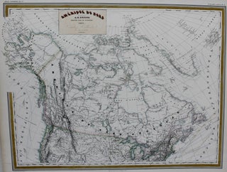
Amerique Du Nord
Paris: c. 1857. Size : 428x559 (mm), 16.85x22.01 (Inches), Coloring: Original Outline Coloring, Category: Maps Canada;. Size : 428x559 (mm), 16.85x22.01 (Inches), Coloring: Original Outline Coloring, Category: Maps Canada;.
Paris: c. 1857. Size : 428x559 (mm), 16.85x22.01 (Inches), Coloring: Original Outline Coloring, Category: Maps Canada;. Size : 428x559 (mm), 16.85x22.01 (Inches), Coloring: Original Outline Coloring, Category: Maps Canada;.
Paris: C. Dentu, 1802. Notes: Mackenzie was born in Stornoway in the Hebrides. In 1774 his family moved to New York, and then to Montreal in 1776 during the American Revolution. In 1779 he obtained a job with the North West Company, on whose behalf he travelled to Lake Athabasca.....

Torino, Italy: 1807. Size : 222x271 (mm), 8.75x10.625 (Inches), Coloring: Hand Colored, Category: ; Maps Canada. Size : 222x271 (mm), 8.75x10.625 (Inches), Coloring: Hand Colored, Category: ; Maps Canada.
![Item #M9557 [ Native Hunting Around Lake Huron ]. Baron De Lahontan](https://alexandremaps.cdn.bibliopolis.com/pictures/M9557.jpg?width=320&height=427&fit=bounds&auto=webp&v=1646686465)
The Hague: Les Freres L’Honore, Marchand Libraires, c.1703. Notes: A fascinating map that shows the hunting practices of the Indian population in the United States and Canada during the early 18th century. , Size : 140x106 (mm), 5.51x4.17 (Inches), Coloring: Hand Colored, Category: Maps Canada;. Notes: A fascinating map that.....

Paris: 1744. Size : 245x380 (mm), 9.625x15 (Inches), Coloring: Black & White, Category: ; Maps Canada; Maps Ocean Atlantic; Maps United States. Size : 245x380 (mm), 9.625x15 (Inches), Coloring: Black & White, Category: ; Maps Canada; Maps Ocean Atlantic; Maps United States.
Paris: Carez, J, 1825. Notes: With surrounding French letterpress text within 455mm x 610mm netalines. Large title above neatline., Size : 250x352 (mm), 9.875x13.875 (Inches), Coloring: Original Hand Coloring, Reference: Atlas Reference: Phillips, P. "A List of Geographical Atlases in the Library of Congress", #1176, Category: ; Maps Canada. Notes.....
Rome: 1797. Notes: Cassini's uncommon six-sheet map of the United States from his "Huovo Atlante Geografico Universale". Cassini drew largely from the Zatta-Mitchell map of North America. "The map presents a fair summary of what continental Europeans understood of the new-born United States at the end of the 18th century.".....
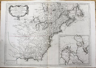
Paris: Guedeville, 1719. Notes: The map is from the " Atlas Historique." This map is Chatelain's reduced version of N. De Fer's very important four-sheet map of 1718. It is one of the most informative map of French possessions in North America in the early 18th century. The map has.....
Venice: 1776. Notes: Map showing the Great Lakes and the entire eastern North America. An inset map showing Arctic region of Canada (the Hudson Bay and Baffin Bay) and Greenland., Size : 487x664 (mm), 19.17x26.14 (Inches), Coloring: Original Outline Coloring, Category: Maps Canada; Maps United States New England (States); Maps.....
Venice: 1775. Notes: Fine copper engraved map of the Great Lakes region with numerous place and Indian names. It is based on D'Anville's influential map of North America (1746). The map extends from the upper Mississippi River valley east to include most of Lake Ontario, north to James Bay and.....
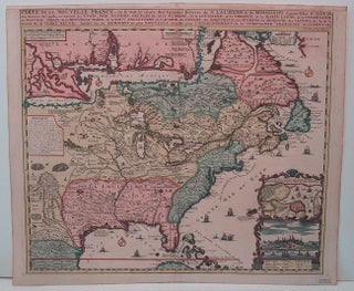
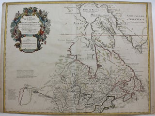
Paris: 1705. Notes: This decorative map focuses on the French possessions in North America. The treatment of French Florida is intriguing. The map shows the United States of America and parts of Southern Canada East of the Mississippi river. "Territorial expansion of New France had reached the Mississipi River with.....
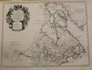
Paris: 1703 but 1718. Notes: Fifth State. Scarce. "Del'Isle's map of Canada is one of the most outstanding maps of Canada of the 17th and early 18th centuries. Typical of all of his work, the information that went into his map of Canada was the result of careful and painstaking.....
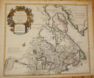
Amsterdam: Covens & Mortier, 1730. Notes: Second state. "De L'Isle's careful research resulted in the first mpa of Canada to present the whole of the Great Lakes correctly. In addition, the postion of the lakes relative to Hudson Bay is also correct, and the Avalon Peninsula is shown much more.....
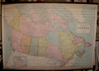
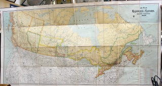
Canada: Department of Mines and Resources, 1947. Size : 1005x1400 (mm), 39.5x55.125 (Inches), Coloring: Printed in Color, Category: ; Maps Canada; Maps Wall Maps. Size : 1005x1400 (mm), 39.5x55.125 (Inches), Coloring: Printed in Color, Category: ; Maps Canada; Maps Wall Maps.
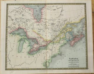
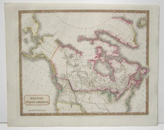
London: Henry Teesdale & Co, 1834. Size : 365x437 (mm), 14.375x17.25 (Inches), Coloring: Hand Colored, Category: ; Maps North America Great Lakes; Maps Canada; Maps Canada East. Size : 365x437 (mm), 14.375x17.25 (Inches), Coloring: Hand Colored, Category: ; Maps North America Great Lakes; Maps Canada; Maps Canada East.
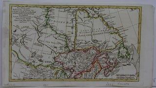
Germany: 1782. Size : 170x295 (mm), 6.75x11.625 (Inches), Coloring: Hand Colored in Outline, Category: Maps Canada; Maps Canada North;. Size : 170x295 (mm), 6.75x11.625 (Inches), Coloring: Hand Colored in Outline, Category: Maps Canada; Maps Canada Hudson Bay / James Bay.
Montreal: Railways of Canada, 1896. Notes: scarce wall map of the railways of Canada on original linen., Size : 1090x2210 (mm), 42.91x87.01 (Inches), Coloring: Printed in Color with Some outline Hand Coloring, Category: Maps Canada; Maps Railroad; Maps Wall Maps;.
London: John Murray, 1868. Size : 105x265 (mm), 4.125x10.375 (Inches), Coloring: Hand Colored, Category: Maps Canada; Maps Railroad. Size : 105x265 (mm), 4.125x10.375 (Inches), Coloring: Hand Colored, Category: Maps Canada; Maps Railroad.
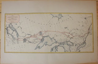
1874. Size : 290x630 (mm), 11.375x24.75 (Inches), Coloring: Hand Colored, Category: Maps Canada; Maps North America Great Lakes; Maps Railroad. Size : 290x630 (mm), 11.375x24.75 (Inches), Coloring: Hand Colored, Category: Maps Canada; Maps North America Great Lakes; Maps Railroad.
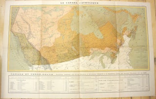
Paris: 1893. Size : 440x920 (mm), 17.32x36.22 (Inches), Coloring: Printed in Color, Category: Maps Canada;. Size : 440x920 (mm), 17.32x36.22 (Inches), Coloring: Printed in Color, Category: Maps Canada;.
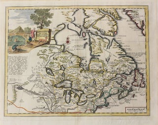
Venice: 1750. Notes: This decorative map of Canada and great lakes is based on important Delisle map of 1703. It is published in "Atlante Novissimo"., Size : 350x447 (mm), 13.78x17.60 (Inches), Coloring: Original Hand Coloring, Reference: LC Philips 594, Kershaw 342, Category: Maps Canada; Maps North America Great Lakes;...
Paris: c. 1718. Notes: Fifth State. Scarce. "De l'Isle's map of Canada is one of the most outstanding maps of Canada of the 17th and early 18th centuries. Typical of all of his work, the information that went into his map of Canada was the result of careful and painstaking.....
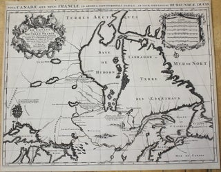
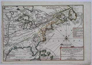
Paris: 1696. Notes: Second state., Size : 461x612 (mm), 18.15x24.09 (Inches), Coloring: Black & White, Reference: Kershaw #174., Category: Maps Canada; Maps North America Great Lakes; Maps Canada North;. Notes: Second state., Size : 461x612 (mm), 18.15x24.09 (Inches), Coloring: Black & White, Reference: Kershaw #174., Category: Maps Canada; Maps Canada.....

London: 1715-1732. Notes: According to McCorkle this is the third state of the map. In Kershaw this map is state E. There are four insets, a large map of coastal South Carolina, and a plan of Charleston, below that is an inset of the eastern portion of North America. At.....
London: Longman, Rees, Orme, Brown & Green, 1829. Notes: Handsome map of Canada and Arctic Regions of North America in strong period hand coloring. Arctic exploration’s interest was high at the time in the British isles. The map shows rivers, settlements, territories of First Nations peoples. British Columbia is divided.....