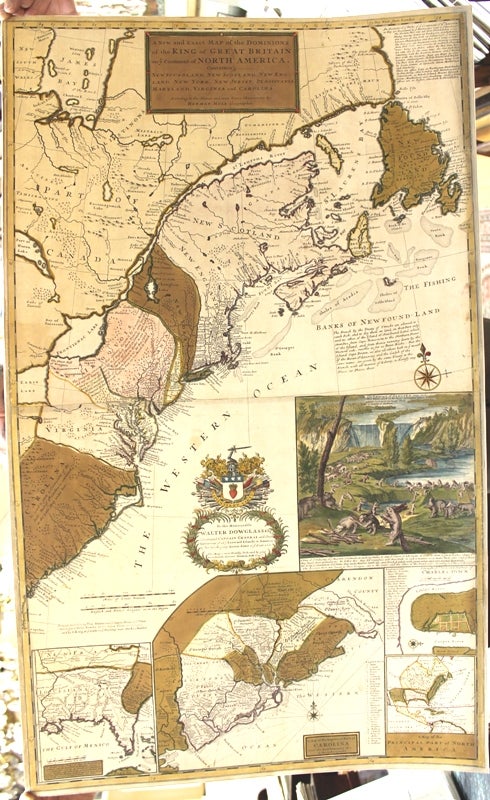
A New and Exact Map of the Dominions of the King of Great Britain on y.e Continent of North America. Containing Newfoundland, New Scotland, New England, New York, New Jersey, Pensilvania, Maryland, Virginia, and Carolina.
London: 1715-1732. Notes: According to McCorkle this is the third state of the map.
In Kershaw this map is state E.
There are four insets, a large map of coastal South Carolina, and a plan of Charleston, below that is an inset of the eastern portion of North America. At lower left is a map of Florida, which is after Thomas Nairne. Above the inset of Charleston is a decorative vignette depicting beavers constructing a damn.
Moll's most celebrated effort as it documents the ongoing dispute between Great Britain and France over the boundaries separating their colonies in America. The map explains the postal routes throughout the British territories and is generally thought to be the first postal map of the colonies. In sections of text Moll describes the Iroquois along the Appalachian Mountains as "...hearty friends to the English..." and explains the terms outlined in the Treaty of Utrecht. The striking beaver scene inset serves to not only symbolize the industriousness needed to settle in America but also the lucrative fur trade spreading wealth and opportunity among the colonies. The name "beaver map" derives from the inset view of Niagara Falls with a very large colony of beavers in the foreground. This is a later issue with Bowles imprint., Size : 1024x618 (mm), 40.31x24.33 (Inches), Coloring: Original Hand Coloring, Reference: McCorkle 715.1; Kershaw 331; Tooley 55; Cumming 158., Category: Maps Canada; Maps United States East;. Very Good, backed on acid free tissue paper for long term preservation. Item #M5998
Notes: According to McCorkle this is the third state of the map.
In Kershaw this map is state E.
There are four insets, a large map of coastal South Carolina, and a plan of Charleston, below that is an inset of the eastern portion of North America. At lower left is a map of Florida, which is after Thomas Nairne. Above the inset of Charleston is a decorative vignette depicting beavers constructing a damn.
Moll's most celebrated effort as it documents the ongoing dispute between Great Britain and France over the boundaries separating their colonies in America. The map explains the postal routes throughout the British territories and is generally thought to be the first postal map of the colonies. In sections of text Moll describes the Iroquois along the Appalachian Mountains as "...hearty friends to the English..." and explains the terms outlined in the Treaty of Utrecht. The striking beaver scene inset serves to not only symbolize the industriousness needed to settle in America but also the lucrative fur trade spreading wealth and opportunity among the colonies. The name "beaver map" derives from the inset view of Niagara Falls with a very large colony of beavers in the foreground. This is a later issue with Bowles imprint., Size : 1024x618 (mm), 40.31x24.33 (Inches), Coloring: Original Hand Coloring, Reference: McCorkle 715.1; Kershaw 331; Tooley 55; Cumming 158., Category: Maps Canada; Maps United States East;.
Price: $21,000.00