
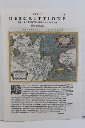
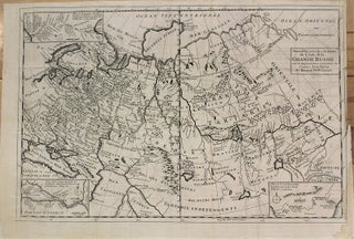
Tartarie
Paris: 1680. Size : 124x176 (mm), 4.875x6.875 (Inches), Coloring: Black & White, Category: ; Maps Russia. Size : 124x176 (mm), 4.875x6.875 (Inches), Coloring: Black & White, Category: ; Maps Russia.
Paris: 1680. Size : 124x176 (mm), 4.875x6.875 (Inches), Coloring: Black & White, Category: ; Maps Russia. Size : 124x176 (mm), 4.875x6.875 (Inches), Coloring: Black & White, Category: ; Maps Russia.
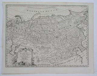
London: 1757. Size : 352x468 (mm), 13.875x18.375 (Inches), Coloring: Black & White, Category: Maps Russia. Size : 352x468 (mm), 13.875x18.375 (Inches), Coloring: Black & White, Category: Maps Russia.
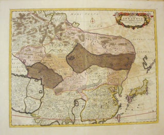
Amsterdam: c. 1680. Notes: Decorative cartouche with two putti., Size : 440x567 (mm), 17.32x22.32 (Inches), Coloring: Original Hand Coloring, Category: Maps Russia;Maps Asia Far East China; Maps Asia Far East Japan & Korea;. Notes: Decorative cartouche with two putti., Size : 440x567 (mm), 17.32x22.32 (Inches), Coloring: Original Hand Coloring, Category.....
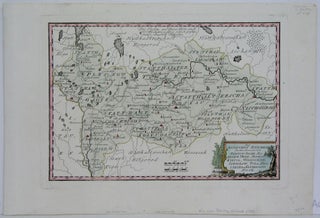
Vienna: 1789. Size : 227x325 (mm), 8.875x12.75 (Inches), Coloring: Hand Colored, Category: Maps Russia. Size : 227x325 (mm), 8.875x12.75 (Inches), Coloring: Hand Colored, Category: Maps Russia.
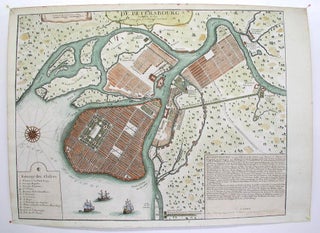
Paris: 1717. Notes: (Stolen)Rare map of the Imperial capital city during the reign of Alexander I with its traditional regular street layout and eleven districts. The map provides excellent detail of the public buildings, docks and shipyards, fortifications, palaces, churches, hospitals, universities, etc, Size : 365x473 (mm), 14.375x18.625 (Inches), Coloring.....
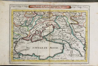
Augsburg, Germany: c.1715. Size : 172x233 (mm), 6.77x9.17 (Inches), Coloring: Original Outline Coloring, Category: Maps Europe Ukraine; Maps Russia; Maps Asia Middle East Caucasus.;. Size : 172x233 (mm), 6.77x9.17 (Inches), Coloring: Original Outline Coloring, Category: Maps Europe Ukraine; Maps Russia; Maps Asia Middle East Caucasus.;.
Augsburg: c. 1720. Notes: The map is flanked by two columns of text and a key located on the right portion of the map., Size : 150x225 (mm), 5.875x8.875 (Inches), Coloring: Hand Colored, Category: ; Maps Russia. Notes: The map is flanked by two columns of text and a key.....
Amsterdam: 1722. Notes: A rare series of maps of various Caspian Ports by Van Keulen., Size : 510x600 (mm), 20.125x23.625 (Inches), Coloring: Black & White, Category: Maps Russia. Notes: A rare series of maps of various Caspian Ports by Van Keulen., Size : 510x600 (mm), 20.125x23.625 (Inches), Coloring: Black &.....
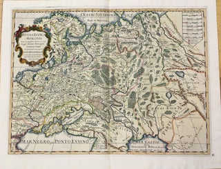
Rome: 1678. Notes: Engraved by Georgio Widman., Size : 420x560 (mm), 16.54x22.05 (Inches), Coloring: Hand Colored, Reference: Shirley (BL Atlases) T.ROSS-1a #32., Category: Maps Russia; Maps Europe Ukraine; Maps Asia Middle East Caucasus.;. Notes: Engraved by Georgio Widman., Size : 420x560 (mm), 16.54x22.05 (Inches), Coloring: Hand Colored, Reference: Shirley (BL.....
Germany: Battista & Giorgio Galignani Fratelli, c. 1598. Notes: An early map of Eastern Asia depicting Japan, China, Russia, Mongolia, and Central Asia. Also shows the North Western parts of North America., Size : 136x178 (mm), 5.35x7.01 (Inches), Coloring: Hand Colored, Category: Maps Asia Continent; Maps Russia;. Notes: An early.....
Amsterdam: I. Covens & C. Mortier, c. 1730. Size : 485x598 (mm), 19.09x23.54 (Inches), Coloring: Original Hand Coloring, Category: Maps Russia;. Size : 485x598 (mm), 19.09x23.54 (Inches), Coloring: Original Hand Coloring, Category: Maps Russia;.
Paris: c.1740. Notes: Map of Russia showing grand Empire of the Czar., Size : 320x482 (mm), 12.60x18.98 (Inches), Coloring: Black & White, Category: Maps Russia;. Notes: Map of Russia showing grand Empire of the Czar., Size : 320x482 (mm), 12.60x18.98 (Inches), Coloring: Black & White, Category: Maps Russia;.
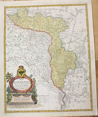
Nuremberg: 1775. Notes: Map of the modern day Belarus and of Russian Lithuania, showing in detail cities, towns, forests, rivers, lakes, and other topographical features. Decorative cartouche bearing the Russian Coat of Arms houses the title. , Size : 570x465 (mm), 22.375x18.25 (Inches), Coloring: Original Hand Coloring, Category: Maps Europe.....
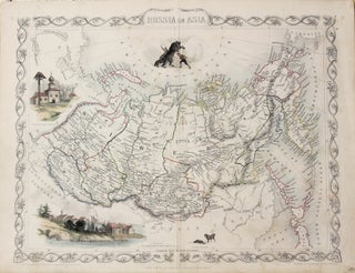
London: John Tallis and Company, 1850. Size : 270x373 (mm), 10.625x14.625 (Inches), Coloring: Original Outline Coloring, Category: Maps Russia. Size : 270x373 (mm), 10.625x14.625 (Inches), Coloring: Original Outline Coloring, Category: Maps Russia.
London, Edinburgh, Dublin: J & F Tallis, 1849. Size : 360x274 (mm), 14.125x10.75 (Inches), Coloring: Original Outline Coloring, Category: Maps Russia. Size : 360x274 (mm), 14.125x10.75 (Inches), Coloring: Original Outline Coloring, Category: Maps Russia.
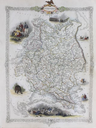
London: Tallis, c.1848. Size : 347x270 (mm), 13.66x10.63 (Inches), Coloring: Original Outline Coloring, Category: Maps Russia; Maps Europe Ukraine; Maps Military;. Size : 347x270 (mm), 13.66x10.63 (Inches), Coloring: Original Outline Coloring, Category: Maps Russia; Maps Europe Ukraine; Maps Military;.
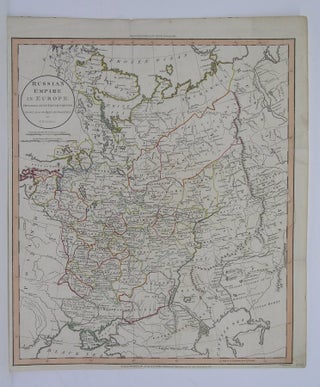
London: 1811. Size : 463x395 (mm), 18.25x15.5 (Inches), Coloring: Original Hand Coloring, Category: Maps Russia. Size : 463x395 (mm), 18.25x15.5 (Inches), Coloring: Original Hand Coloring, Category: Maps Russia.
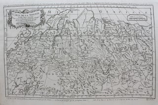
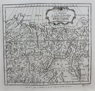
Paris: c. 1754. Notes: A detailed map of Siberia during the mid 18th century. The map extends from the White and Caspian Seas in the west to Irkuckoi Province, Jakutky on the Lena River and regions to the east. Jacques Nicolas Bellin (1703 – 1772) was a French hydrographer, geographer.....
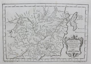
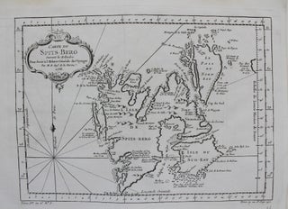
Paris: c.1757. Notes: A detailed map of Manchuria and the eastern Tartary region during the mid 18th century. Jacques Nicolas Bellin (1703 – 1772) was a French hydrographer, geographer, and member of the French intellectual group called the philosophes. He was hydrographer of France's hydrographic office, member of the Académie.....
Paris: c. 1757. Notes: A detailed map of Novaya Zemlya and the northern shores of Russia during the mid 18th century. Jacques Nicolas Bellin (1703 – 1772) was a French hydrographer, geographer, and member of the French intellectual group called the philosophes. He was hydrographer of France's hydrographic office, member.....
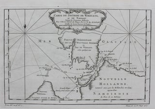
Paris: c. 1764. Notes: A regional map of the Arctic Sea, in particular the Strait of Waeigats, during the mid 18th century. Jacques Nicolas Bellin (1703 – 1772) was a French hydrographer, geographer, and member of the French intellectual group called the philosophes. He was hydrographer of France's hydrographic office.....
Paris: c.1758. Notes: A map of Spitsbergen (Svalbard), Franz Josef Land and Jan Mayan during the mid 18th century. Jacques Nicolas Bellin (1703 – 1772) was a French hydrographer, geographer, and member of the French intellectual group called the philosophes., Size : 217x301 (mm), 8.54x11.85 (Inches), Coloring: Black & White.....
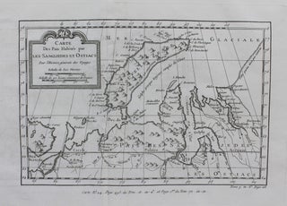
Paris: c. 1758. Notes: A map detailing the archipelago of Novaya Zemlya, the Samoyeds, and part of the Northeast passage during the mid 18th century. Jacques Nicolas Bellin (1703 – 1772) was a French hydrographer, geographer, and member of the French intellectual group called the philosophes., Size : 213x346 (mm).....
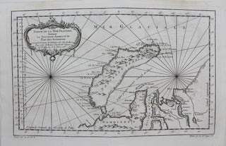
Paris: c.1764. Notes: A detailed map of Russia and the Kamchatkan Peninsula during the mid 18th century. The map has a decorative cartouche and shows the path of an expedition made in 1648 to Kamchatka. , Size : 239x260 (mm), 9.41x10.24 (Inches), Coloring: Black & White, Category: Maps Russia;. Notes.....
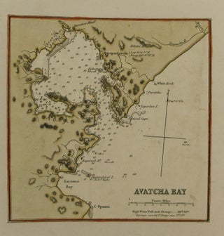
London: James Imray & Son, 1863. Notes: This bay is situated on the Kamchatka peninsula of eastern Russia., Size : 153x151 (mm), 6.02x5.94 (Inches), Coloring: Hand Colored in Outline, Category: Maps Russia; Maps Sea Chart;. Notes: This bay is situated on the Kamchatka peninsula of eastern Russia., Size : 153x151.....