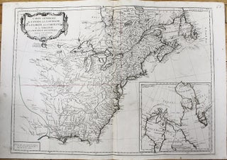
Carte Generale du Canada, de la Louisiane, de la Floride, de la Caroline, de la Virginie, de la Nouvelle Angleterre.
Venice: 1776. Notes: Map showing the Great Lakes and the entire eastern North America. An inset map showing Arctic region of Canada (the Hudson Bay and Baffin Bay) and Greenland., Size : 487x664 (mm), 19.17x26.14 (Inches), Coloring: Original Outline Coloring, Category: Maps Canada; Maps United States New England (States); Maps.....