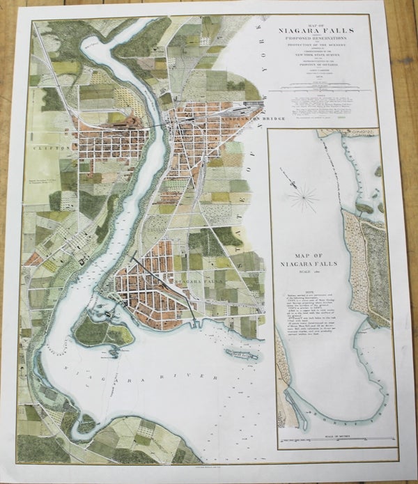
Map of Niagara Falls showing Proposed Reservations for Protection of the Scenery.
New York: Julius Bien Photolith, 1879. Notes: Rare large scale and detailed map of the Niagara Falls and the adjacent cities.
Detailed map of the Niagara Falls border between the province of Ontario and the state of New York.
Map includes roads, railroads, bridges, international boundary lines, county lines, churches, schools, cemeteries, Land Contours, Depressions, Cliffs, lakes, marshes and ponds.
The map depicts the two cities of Niagara Falls on the either sides of the border. , Size : 700x553 (mm), 27.56x21.77 (Inches), Coloring: Hand Colored, Category: Maps Canada Ontario South Niagara; Maps City Maps;. Very Good, backed on acid free tissue paper for long term preservation. Item #M9984
Notes: Rare large scale and detailed map of the Niagara Falls and the adjacent cities.
Detailed map of the Niagara Falls border between the province of Ontario and the state of New York.
Map includes roads, railroads, bridges, international boundary lines, county lines, churches, schools, cemeteries, Land Contours, Depressions, Cliffs, lakes, marshes and ponds.
The map depicts the two cities of Niagara Falls on the either sides of the border. , Size : 700x553 (mm), 27.56x21.77 (Inches), Coloring: Hand Colored, Category: Maps Canada Ontario South Niagara; Maps City Maps;.
Price: $1,250.00