
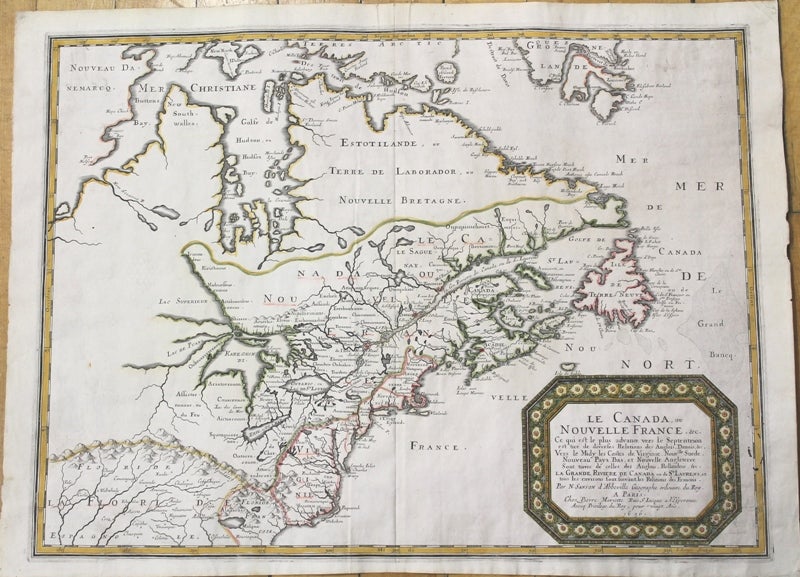
Le Canada, ou Nouvelle France, &c. Ce qui est le plus advance vers le Septentrion est tire de diverses Replations des Anglois, Danois, &c. Vers le Midy les Costes de Virginie, Nouv.lle Suede, Nouveau Pays Bas, et Nouvelle Angleterre Sont tirees de celles des Anglois, Hollandois, &c. La Grande Riviere de Canada ou de St Laurens, et tous les environs sont suivant les Ralations des Francois.
Paris: Mariette, Pierre, c.1656. Notes: "Nicolas Sanson's (1600-1667) involvement in cartography began with the maps and illustrations he drew for publication in his own historical books. Nicolas Sanson was the outstanding French cartographer of the mid to late seventeenth century and is considered the founder of the French school of cartography. Due largely to the Sanson family map-publishing business, the patronage of Louis XIV, and the work of the newly-formed Académie royale des sciences, the seat of cartography shifted from the Low Countries to France in the latter part of the seventeenth century. "This folio map by Sanson, published in 1656, influenced the cartography for the next fifty years. The eastern Great Lakes region is remarkably accurate, with the western ends of the lakes undefined for lack of reliable information. The possibility of a northwest passage at the bottom of Button's Bay was also to influence a considerable number of cartographers for the rest of the century" -Kershaw "This is the most influential record of the French establishments in North America in the middle of the seventeenth century. It is based on the Jesuit Relations and shows an accurate course of the St. Lawrence and the Great Lakes in more or less their proper locations. Another source was Sanson's own map of North America, published in 1650. "The discoveries and observations of Samuel de Champlain and the Jesuit fathers Jogues and Raymbault are shown, as well as much information gleaned from the reports of the many fur-traders in Canada at the time, together with hearsay information supplied by travellers among the Indians. Note however the unusual orientation of Lake Michigan, probably gathered from Bartheemy Vimont's travels of 1642 in an east to west direction along the northern shores of the lake. Many other names here are Indian in origin." -Goss " , Size : 405x540 (mm), 15.94x21.26 (Inches), Coloring: Hand Colored, Reference: Kershaw 133; Goss, The Mapping of North America, map 33; Karpinski X & Plate III; Kaufman # 3; Armstrong # 10; Cumming # 48 & Plate 30; Schwartz & Ehrengerg p.114, Category: Maps Canada; Maps Canada East; Maps North America Great Lakes;. Very Good. Item #M9956
Notes: "Nicolas Sanson's (1600-1667) involvement in cartography began with the maps and illustrations he drew for publication in his own historical books. Nicolas Sanson was the outstanding French cartographer of the mid to late seventeenth century and is considered the founder of the French school of cartography. Due largely to the Sanson family map-publishing business, the patronage of Louis XIV, and the work of the newly-formed Académie royale des sciences, the seat of cartography shifted from the Low Countries to France in the latter part of the seventeenth century. "This folio map by Sanson, published in 1656, influenced the cartography for the next fifty years. The eastern Great Lakes region is remarkably accurate, with the western ends of the lakes undefined for lack of reliable information. The possibility of a northwest passage at the bottom of Button's Bay was also to influence a considerable number of cartographers for the rest of the century" -Kershaw "This is the most influential record of the French establishments in North America in the middle of the seventeenth century. It is based on the Jesuit Relations and shows an accurate course of the St. Lawrence and the Great Lakes in more or less their proper locations. Another source was Sanson's own map of North America, published in 1650. "The discoveries and observations of Samuel de Champlain and the Jesuit fathers Jogues and Raymbault are shown, as well as much information gleaned from the reports of the many fur-traders in Canada at the time, together with hearsay information supplied by travellers among the Indians. Note however the unusual orientation of Lake Michigan, probably gathered from Bartheemy Vimont's travels of 1642 in an east to west direction along the northern shores of the lake. Many other names here are Indian in origin." -Goss " , Size : 405x540 (mm), 15.94x21.26 (Inches), Coloring: Hand Colored, Reference: Kershaw 133; Goss, The Mapping of North America, map 33; Karpinski X & Plate III; Kaufman # 3; Armstrong # 10; Cumming # 48 & Plate 30; Schwartz & Ehrengerg p.114, Category: Maps Canada; Maps Canada East; Maps North America Great Lakes;.
Price: $6,500.00