![Item #M9844 [ Map of Iran ]. Col Abdul-Razzagh Khan.](https://alexandremaps.cdn.bibliopolis.com/pictures/M9844.jpg?width=768&height=1000&fit=bounds&auto=webp&v=1646686541)
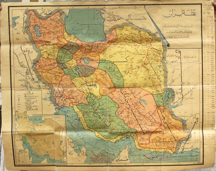
[ Map of Iran ]
Paris: E. Girard Geographe-Editeur, c.1935. Notes: A decorative and highly scarce wall map of Iran published in Paris in the early twentieth century. The map is based on earlier maps of Iran that were published in France, Russia and Iran. The map depicts in detail its various provinces, main roads, railroads, rivers, boundaries, main cities, towns, ports, and other geographical features Together with the Telegraphic paths. Included is a sidebar with information on its regions' distance from the capital, as well as elevation information. All inscriptions and description and the names of the cities and provinces are shown in Persian (mode Arabic 'naskh' and Persian 'nasta liq' ). The external boundaries are shown. Note that the Persian Gulf is named as the Khalij-i Bandar-Bushihr and the Caspian sea is Bahr-i Khazar or Darya-yi-Mazandaran. In the lower left there is a geographical inset map of Iran.
, Size : 930x1103 (mm), 36.61x43.43 (Inches), Coloring: Printed in Color, Category: Maps Asia Middle East Iran, Iraq; Maps 20th Century Maps; Maps Wall Maps;. Very Good, backed on original linen. Item #M9844
Notes: A decorative and highly scarce wall map of Iran published in Paris in the early twentieth century. The map is based on earlier maps of Iran that were published in France, Russia and Iran. The map depicts in detail its various provinces, main roads, railroads, rivers, boundaries, main cities, towns, ports, and other geographical features Together with the Telegraphic paths. Included is a sidebar with information on its regions' distance from the capital, as well as elevation information. All inscriptions and description and the names of the cities and provinces are shown in Persian (mode Arabic 'naskh' and Persian 'nasta liq' ). The external boundaries are shown. Note that the Persian Gulf is named as the Khalij-i Bandar-Bushihr and the Caspian sea is Bahr-i Khazar or Darya-yi-Mazandaran. In the lower left there is a geographical inset map of Iran.
, Size : 930x1103 (mm), 36.61x43.43 (Inches), Coloring: Printed in Color, Category: Maps Asia Middle East Iran, Iraq; Maps 20th Century Maps; Maps Wall Maps;.
Price: $5,750.00