![Item #M9767 City of Toronto Plate 17 [Massey St., Robinson St., Markham St., Defoe St.]. Charles E. Goad.](https://alexandremaps.cdn.bibliopolis.com/pictures/M9767.jpg?width=768&height=1000&fit=bounds&auto=webp&v=1646686524)
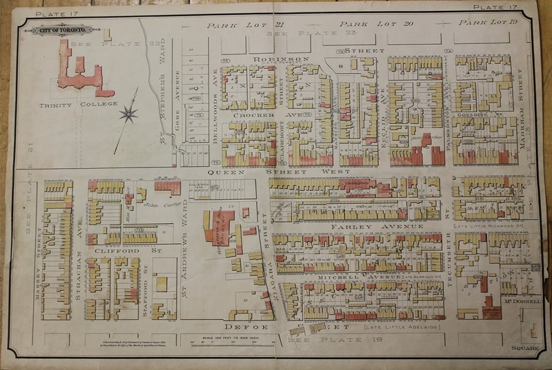
City of Toronto Plate 17 [Massey St., Robinson St., Markham St., Defoe St.]
Toronto: Charles E. Goad, 1890. Notes: English railway engineer, went to Canada in 1868, where he did not pursue engineering, but became a representative for the Sanborn Company which published fire insurance plans. From 1875 Goad began to compile and publish his own large-scale plans of Canadian towns from a base in Montreal, and soon became the largest private mapmaker in Canada. By 1885 Charles Goad had returned to Britain and established a branch in London. Goad’s highly detailed plans included information on property holdings, building construction, use and contents, and, like Sanborn’s, functioned as Fire Insurance Plans. Once leased to an insurance company the map volumes were regularly updated by a team of workers who over-pasted sections with new information onto the existing maps, some of them building up to many layers. Goad’s business rapidly expanded to cover the cities and industrial areas of Britain, Denmark, France, Egypt, Turkey, Venezuela, Bermuda, Mexico and South Africa. After his death the company was run by his three sons. Copyrights and assets of the Canadian branch of the company were sold to The Underwriter’s Survey Bureau in 1931., Size : 435x660 (mm), 17.13x25.98 (Inches), Coloring: Printed in Color, Reference: Hayward, R.J. Fire insurance plans in the National Map Collection (Ottawa 1977); Hayward, R.J. “Chas Goad and fire insurance cartography’, in Proceedings (of the Association of Canadian Map Libraries, Eighth Annual Conference, Toronto June 9-13, 1974) pp.51-72; Tooley, "Tooley's Dictionary of Mapmakers Revised Edition E - J", p178., Category: Maps City Maps; Maps Canada Ontario South York Toronto;. Very Good. Item #M9767
Notes: English railway engineer, went to Canada in 1868, where he did not pursue engineering, but became a representative for the Sanborn Company which published fire insurance plans. From 1875 Goad began to compile and publish his own large-scale plans of Canadian towns from a base in Montreal, and soon became the largest private mapmaker in Canada. By 1885 Charles Goad had returned to Britain and established a branch in London. Goad’s highly detailed plans included information on property holdings, building construction, use and contents, and, like Sanborn’s, functioned as Fire Insurance Plans. Once leased to an insurance company the map volumes were regularly updated by a team of workers who over-pasted sections with new information onto the existing maps, some of them building up to many layers. Goad’s business rapidly expanded to cover the cities and industrial areas of Britain, Denmark, France, Egypt, Turkey, Venezuela, Bermuda, Mexico and South Africa. After his death the company was run by his three sons. Copyrights and assets of the Canadian branch of the company were sold to The Underwriter’s Survey Bureau in 1931., Size : 435x660 (mm), 17.13x25.98 (Inches), Coloring: Printed in Color, Reference: Hayward, R.J. Fire insurance plans in the National Map Collection (Ottawa 1977); Hayward, R.J. “Chas Goad and fire insurance cartography’, in Proceedings (of the Association of Canadian Map Libraries, Eighth Annual Conference, Toronto June 9-13, 1974) pp.51-72; Tooley, "Tooley's Dictionary of Mapmakers Revised Edition E - J", p178., Category: Maps City Maps; Maps Canada Ontario South York Toronto;.
Price: $375.00