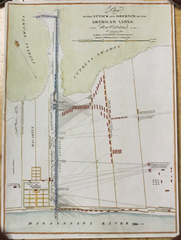
Plan of the Attack and Defence of the American Lines below New Orleans on the 8th January, 1815
Philadelphia: John Conrad, c. 1816. Notes: A map showing battle lines during the Battle of New Orleans during the War of 1812.
The Battle of New Orleans was an engagement fought between January 8 and January 18, 1815, constituting the final major and most one-sided battle of the War of 1812. American combatants, commanded by Major General Andrew Jackson, prevented the British Army, Royal Marines and a large Royal Navy fleet, commanded by Admiral Alexander Cochrane and General Edward Pakenham, from seizing New Orleans as a strategic tool to end the war. The Treaty of Ghent was signed on December 24, 1814 (but was not ratified by the US Government until February 1815), and hostilities would continue without the involved parties knowing about the Treaty, until January 18 when all of the British forces had retreated, finally putting an end to the Battle of New Orleans., Size : 378x292 (mm), 14.88x11.50 (Inches), Coloring: Hand Colored, Category: Maps Military; Maps United States South Louisiana;. Very Good, backed on acid free tissue paper for long term preservation. Item #M9691
Notes: A map showing battle lines during the Battle of New Orleans during the War of 1812.
The Battle of New Orleans was an engagement fought between January 8 and January 18, 1815, constituting the final major and most one-sided battle of the War of 1812. American combatants, commanded by Major General Andrew Jackson, prevented the British Army, Royal Marines and a large Royal Navy fleet, commanded by Admiral Alexander Cochrane and General Edward Pakenham, from seizing New Orleans as a strategic tool to end the war. The Treaty of Ghent was signed on December 24, 1814 (but was not ratified by the US Government until February 1815), and hostilities would continue without the involved parties knowing about the Treaty, until January 18 when all of the British forces had retreated, finally putting an end to the Battle of New Orleans., Size : 378x292 (mm), 14.88x11.50 (Inches), Coloring: Hand Colored, Category: Maps Military; Maps United States South Louisiana;.
Price: $875.00