![Item #M9175 Atlas City of Toronto Plate 46[The Don River, Randolph Ave., Leslie St., Victor Ave.]. Charles E. Goad.](https://alexandremaps.cdn.bibliopolis.com/pictures/M9175.jpg?width=768&height=1000&fit=bounds&auto=webp&v=1646686381)
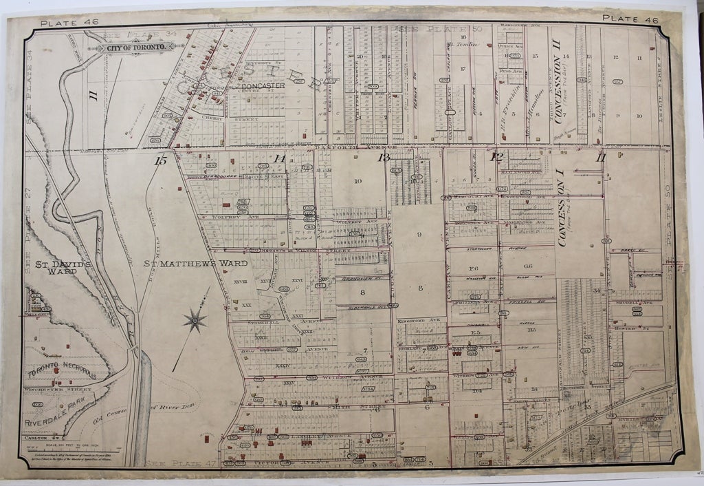
Atlas City of Toronto Plate 46
[The Don River, Randolph Ave., Leslie St., Victor Ave.]
Toronto: c.1890. Notes: This map is from the second major edition of Goad's Atlas of Toronto. The first edition was published in 1884 but the city began to grow so rapidly that new editions were published. Charles Edward Goad (1848 - 1910) was a noted cartographer and civil engineer. Goad is most noted for his insurance surveys of cities in Canada, Great Britain, and elsewhere. Fire insurance companies needed to know in detail the nature and size of buildings, width of streets, construction, building materials and the proximity of fire services and water supplies in order to estimate appropriate premiums. Goad established a company (the Charles E. Goad Company) in 1875 in Montreal, Canada to produce maps to provide this information. These and like maps are now referred to as Goad maps., Size : 453x667 (mm), 17.83x26.26 (Inches), Coloring: Black & White, Reference: Hayward, R.J. Fire insurance plans in the National Map Collection (Ottawa 1977); Hayward, R.J. “Chas Goad and fire insurance cartography’, in Proceedings (of the Association of Canadian Map Libraries, Eighth Annual Conference, Toronto June 9-13, 1974) pp.51-72; Tooley, "Tooley's Dictionary of Mapmakers Revised Edition E - J", p178., Category: Maps Canada Ontario South York Toronto; Maps City Maps;. Very Good. Laid on acid free tissue paper for long term preservation. Item #M9175
Notes: This map is from the second major edition of Goad's Atlas of Toronto. The first edition was published in 1884 but the city began to grow so rapidly that new editions were published. Charles Edward Goad (1848 - 1910) was a noted cartographer and civil engineer. Goad is most noted for his insurance surveys of cities in Canada, Great Britain, and elsewhere. Fire insurance companies needed to know in detail the nature and size of buildings, width of streets, construction, building materials and the proximity of fire services and water supplies in order to estimate appropriate premiums. Goad established a company (the Charles E. Goad Company) in 1875 in Montreal, Canada to produce maps to provide this information. These and like maps are now referred to as Goad maps., Size : 453x667 (mm), 17.83x26.26 (Inches), Coloring: Black & White, Reference: Hayward, R.J. Fire insurance plans in the National Map Collection (Ottawa 1977); Hayward, R.J. “Chas Goad and fire insurance cartography’, in Proceedings (of the Association of Canadian Map Libraries, Eighth Annual Conference, Toronto June 9-13, 1974) pp.51-72; Tooley, "Tooley's Dictionary of Mapmakers Revised Edition E - J", p178., Category: Maps Canada Ontario South York Toronto; Maps City Maps;.
Price: $475.00