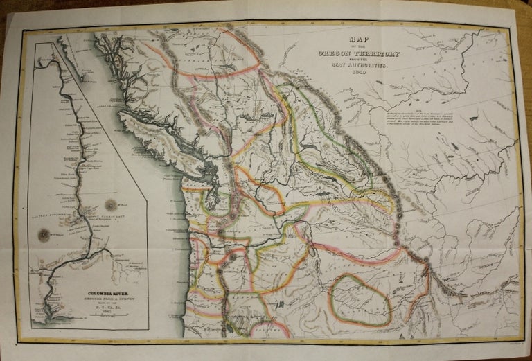
Map of the Oregon Territory from the best authorities.
Washington: c.1849. Notes: Based on an earlier map by Charles Wilkes done on 1841. One of the most significant maps of the Northwest after the Lewis & Clark expedition. Wheat refers to the map as "really quite extraordinary" and one of the most detailed of this region to be published. The map covers the entire region west from the Black Hills, north to above the 50th parallel and south to the Sacramento River. He was the first to use astronomical instruments for observation and the first to name and chart the Antarctic continent. In 1841, he was commanded to explore the Northwestern Coast of America including the Columbia River, and the coast of California, with special reference to the Bay of San Francisco. Wilkes' report was published in 1845. The Wilkes Expedition explored the South Pacific Islands, Australia and New Zealand, the Hawaiian Islands, the Northwest Coast, California, Singapore, the Cape of Good Hope and St. Helena. His greatest achievement was the expedition into the Antarctic in the winter of 1839-40: Wilks was the first to announce the Antarctic continent. Forbes, "Hawaiian National Bibliography', 1903; Haskell, 12; Hill, p.325; Magnificent, Voyagers. The U.S. Exploring Expedition', ed H.J. Viola and C. Margolis, Smithsonian Institution, 1985.
Inset: Columbia River, reduced from a survey / made by the U.S. Ex. Ex., 1841.
, Size : 211x334 (mm), 8.31x13.15 (Inches), Coloring: Hand Colored, Category: Maps United States West Washington & Oregon;. Very Good. Item #M9028
Notes: Based on an earlier map by Charles Wilkes done on 1841. One of the most significant maps of the Northwest after the Lewis & Clark expedition. Wheat refers to the map as "really quite extraordinary" and one of the most detailed of this region to be published. The map covers the entire region west from the Black Hills, north to above the 50th parallel and south to the Sacramento River. He was the first to use astronomical instruments for observation and the first to name and chart the Antarctic continent. In 1841, he was commanded to explore the Northwestern Coast of America including the Columbia River, and the coast of California, with special reference to the Bay of San Francisco. Wilkes' report was published in 1845. The Wilkes Expedition explored the South Pacific Islands, Australia and New Zealand, the Hawaiian Islands, the Northwest Coast, California, Singapore, the Cape of Good Hope and St. Helena. His greatest achievement was the expedition into the Antarctic in the winter of 1839-40: Wilks was the first to announce the Antarctic continent. Forbes, "Hawaiian National Bibliography', 1903; Haskell, 12; Hill, p.325; Magnificent, Voyagers. The U.S. Exploring Expedition', ed H.J. Viola and C. Margolis, Smithsonian Institution, 1985.
Inset: Columbia River, reduced from a survey / made by the U.S. Ex. Ex., 1841.
, Size : 211x334 (mm), 8.31x13.15 (Inches), Coloring: Hand Colored, Category: Maps United States West Oregon;.
Price: $575.00