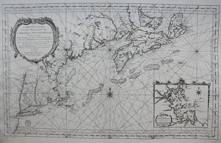
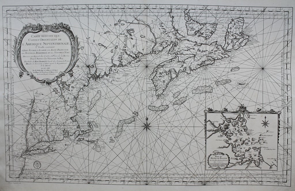
Carte Reduite Des Costes Orientales de L'Amerique Septentrionale Ire. Feuille contenant L'Isle Royale, L'Accadie, La Baye Francoise, La Nouvelle Angleterre et la Nouvelle Yorc. Dressee au Depost des Cartes et Plans de la Marine Pour le Service des Vaisseaux du Roy Par Ordre de MDE Machault Garde des Sceaux de France Ministre et Secretaire d Etat ayant le Departement de la Marine
Paris: Department de la Marine, 1757. Notes: A magnificent mid 18th century sea chart of the Atlantic coast of north eastern United States, stretching from Cape Breton to New Jersey. Rivers, mountain ranges, lakes, and coastal features are depicted in fine detail. With an inset of the Boston and vicinity in the lower right. A fine example with dark impressions on blue paper. An important map of the French-Indian war, of new England and vicinity.
Jacques Nicolas Bellin (1703-1772) was a prominent French hydrographer, geographer, and member of the French intellectual group called the philosophes. Over a 50 year career, he produced a large number of maps of particular interest to the Ministère de la Marine.
, Size : 535x858 (mm), 21.06x33.78 (Inches), Coloring: Black & White, Category: Maps United States East; Maps Canada East; Maps City Maps;. Very Good, Item #M8872
Notes: A magnificent mid 18th century sea chart of the Atlantic coast of north eastern United States, stretching from Cape Breton to New Jersey. Rivers, mountain ranges, lakes, and coastal features are depicted in fine detail. With an inset of the Boston and vicinity in the lower right. A fine example with dark impressions on blue paper. An important map of the French-Indian war, of new England and vicinity.
Jacques Nicolas Bellin (1703-1772) was a prominent French hydrographer, geographer, and member of the French intellectual group called the philosophes. Over a 50 year career, he produced a large number of maps of particular interest to the Ministère de la Marine.
, Size : 535x858 (mm), 21.06x33.78 (Inches), Coloring: Black & White, Category: Maps United States East; Maps Canada East; Maps City Maps;.
Price: $3,750.00