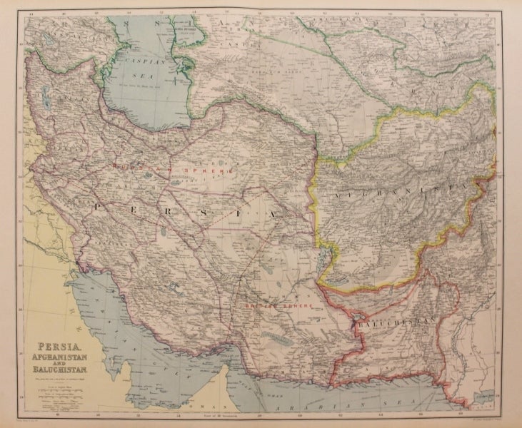
Persia, Afghanistan and Baluchistan.
London: George Philip & Son, 1890. Notes: Map of Afghanistan in great details highlighted in yellow, together showing map of Persia during the final years of the reign of Emperor Naser al-Din Shah of Qajar when the "Great Game" was at its height. Shows in detail the various provinces of Persia, elevation features, major towns, lakes, and deserts. Also illustrated on the map are boundaries of the Russian and British spheres of influence of that country, highlighting the geopolitical realities of the time.
The Royal Geographical Society (with the Institute of British Geographers) is a distinguished British learned society founded in 1830 for the advancement of geographical sciences.
, Size : 500x597 (mm), 19.69x23.50 (Inches), Coloring: Printed in Color, Category: Maps Asia Middle East Iran, Iraq; Maps Asia Central Afghanistan, Pakistan;. Very Good. Item #M8776
Notes: Map of Afghanistan in great details highlighted in yellow, together showing map of Persia during the final years of the reign of Emperor Naser al-Din Shah of Qajar when the "Great Game" was at its height. Shows in detail the various provinces of Persia, elevation features, major towns, lakes, and deserts. Also illustrated on the map are boundaries of the Russian and British spheres of influence of that country, highlighting the geopolitical realities of the time.
The Royal Geographical Society (with the Institute of British Geographers) is a distinguished British learned society founded in 1830 for the advancement of geographical sciences.
, Size : 500x597 (mm), 19.69x23.50 (Inches), Coloring: Printed in Color, Category: Maps Asia Middle East Iran, Iraq; Maps Asia Central Afghanistan, Pakistan;.
Price: $375.00