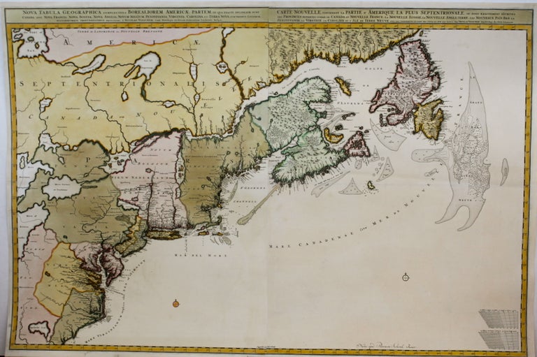
Nova Tabula Geographica complectens Borealiorem Americae Partem…; Carte Nouvelle Contenant la Partie D’Amerique la Plus Septentrionale…
Amsterdam: Peter Schenk, c.1696; c.1717. Notes: The left sheet is a first state map, while the right sheet is a third state map. (Philip Burden, 439).
"This beautiful map . . . is probably the most detailed delineation of the Coastline from the Carolinas to Labrador drawn in the 17th Century. . . . The Cartography of the Atlantic Seacoast is exceptional for the period, but the representation of the interior is almost entirely conjectural. The Del-Mar-Va peninsula is shown in a distinctive shape, with the portion south of Delaware Bay too wide and curving to the east. The map is important to a Maryland-Chesapeake collection primarily because it as later copied by Johann Baptiste Homann in the Maryland-Delmarva Peninsula area . . . " (The Maryland Historical Society). , Size : 600x905 (mm), 23.62x35.63 (Inches), Coloring: Original Hand Coloring, Category: Maps United States East; Maps Canada East; Maps North America Great Lakes;. Very Good, The two sheets are joined, laid down on acid free tissue paper for long term preservation. Item #M8714
Notes: The left sheet is a first state map, while the right sheet is a third state map. (Philip Burden, 439).
"This beautiful map . . . is probably the most detailed delineation of the Coastline from the Carolinas to Labrador drawn in the 17th Century. . . . The Cartography of the Atlantic Seacoast is exceptional for the period, but the representation of the interior is almost entirely conjectural. The Del-Mar-Va peninsula is shown in a distinctive shape, with the portion south of Delaware Bay too wide and curving to the east. The map is important to a Maryland-Chesapeake collection primarily because it as later copied by Johann Baptiste Homann in the Maryland-Delmarva Peninsula area . . . " (The Maryland Historical Society). , Size : 600x905 (mm), 23.62x35.63 (Inches), Coloring: Original Hand Coloring, Category: Maps United States East; Maps Canada East; Maps North America Great Lakes;.
Price: $3,500.00