
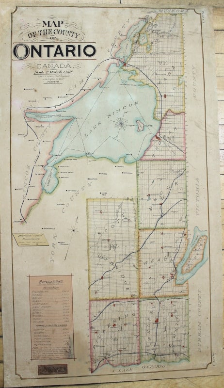
Map of the County of Ontario
Toronto: Minister of Agriculture, 1895. Notes: Very scarce large map of the County of Ontario prepared by the prominent English engineer Charles E. Goad and published in Toronto. The map depicts schools, railways, county roads, elevations, concession numbers, lot numbers and side roads. The map also shows population and statistical numbers of various townships in the County.
Ontario County was the name of two historic counties in the Canadian province of Ontario. Ontario County south of the Trent-Severn Waterway and about half of adjacent Durham County were amalgamated as the Regional Municipality of Durham., Size : 930x495 (mm), 36.61x19.49 (Inches), Coloring: Hand Colored in Outline, Category: Maps Canada Ontario South Durham;. Very Good; laid down on acid free canvas for long term preservation. Item #M7841
Notes: Very scarce large map of the County of Ontario prepared by the prominent English engineer Charles E. Goad and published in Toronto. The map depicts schools, railways, county roads, elevations, concession numbers, lot numbers and side roads. The map also shows population and statistical numbers of various townships in the County.
Ontario County was the name of two historic counties in the Canadian province of Ontario. Ontario County south of the Trent-Severn Waterway and about half of adjacent Durham County were amalgamated as the Regional Municipality of Durham., Size : 930x495 (mm), 36.61x19.49 (Inches), Coloring: Hand Colored in Outline, Category: Maps Canada Ontario South Durham;.
Price: $2,500.00