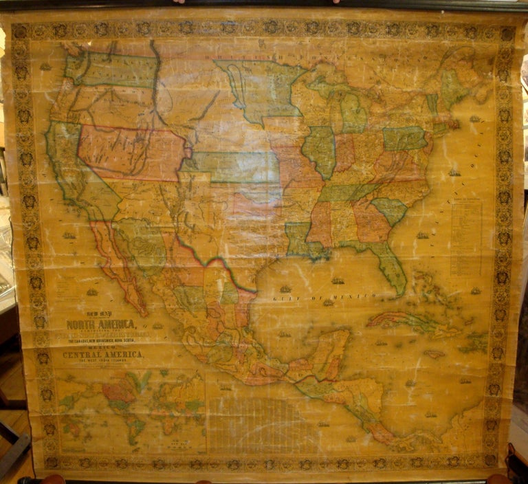
New Map of that Portion of North America, Exhibiting the United States and Territories, the Canadas, New Brunswick, Nova Scotia, and Mexico, Also Central America, and the West India Islands. Compiled from the Most Recent Surveys, and Authentic Sources.
Baltimore: Jacob Monk, 1854. Notes: Inset map of the world sits beneath the title in the lower left corner. It is centred on the Americas and charts the course of Wilkes' circumnavigation of the globe in the 1840s. To its right sits an index of counties and towns. Above the title on the left side are a legend and scale. On the right by the mid margin is a table of distances. The oceans are decorated with tall ships, and the whole map sits within a decorative floral border.
This map marks the dawn of the Manifest Destiny era of American history. Soon after the American victory of Mexico, large new states and territories were carved out from the newly acquired land. Here we see the newly formed California and Texas, along with the Oregon and Washington territories securing the country's claim to the Pacific coast. With California's gold rush getting into full swing, the map accentuates many details of that state's gold region. North-South tensions are revealed in the ambiguity of the central states and territories: Northern interests sought to create a massive Nebraska territory which would have included present-day Kansas; however, Southern lawmakers pressed Congress to make two separate territories., Size : 1405x1500 (mm), 55.31x59.06 (Inches), Coloring: Original Hand Coloring, Reference: Wheat 794 (earlier edition); Rumsey 603., Category: Maps Central America; Maps North America; Maps West Indies Whole; Maps Wall Maps;. Some minor discolourations, and some marginal chipping and staining not affecting the map, altogether a very good copy, laid down on original canvas as a scroll on two wooden rods. Item #M7535
Notes: Inset map of the world sits beneath the title in the lower left corner. It is centred on the Americas and charts the course of Wilkes' circumnavigation of the globe in the 1840s. To its right sits an index of counties and towns. Above the title on the left side are a legend and scale. On the right by the mid margin is a table of distances. The oceans are decorated with tall ships, and the whole map sits within a decorative floral border.
This map marks the dawn of the Manifest Destiny era of American history. Soon after the American victory of Mexico, large new states and territories were carved out from the newly acquired land. Here we see the newly formed California and Texas, along with the Oregon and Washington territories securing the country's claim to the Pacific coast. With California's gold rush getting into full swing, the map accentuates many details of that state's gold region. North-South tensions are revealed in the ambiguity of the central states and territories: Northern interests sought to create a massive Nebraska territory which would have included present-day Kansas; however, Southern lawmakers pressed Congress to make two separate territories., Size : 1405x1500 (mm), 55.31x59.06 (Inches), Coloring: Original Hand Coloring, Reference: Wheat 794 (earlier edition); Rumsey 603., Category: Maps Central America; Maps North America; Maps West Indies Whole; Maps Wall Maps;.
Price: $2,200.00