
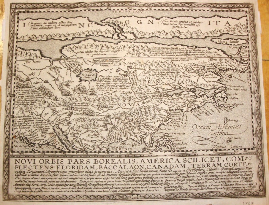
Novi Orbis Pars Borealis, AmericaScilicet, Complectens Floridam, Baccalaon, Canadam...
Cologne, Germany: 1600. Notes: "In 1600 Matthias Quad brought out his general atlas of the world. This was largely an expansion of his earlier Europae totius orbis terrarum of 1592. Quad employed Johannes Bussemacher to engrave this attractive map of North America which is largely a reduced version of Cornelis de Jode's Americae Pars Borealis. De Jode was the first to make use of both John White and Jacques le Moyne's east coast cartography, though he inaccurately placed it. Quad here continues the mistake of placing the nomenclature of Virginia too far north. A long narrow waterway to the north encourages the belief in a North West Passage; Lago de Conibas makes its by now usual appearance. Some names have been surprisingly left out, notably Bermuda, St. Augustine, Roanoke and Chesapeake. A curious "second" peninsula is shown to the west of Florida which could be an early representation of the Mississippi delta. Below the map is a panel with descriptive text." -Burden
Matthias Quad (1557–1613) was born and learnt engraving in the Netherlands. He collaborated with the Cologne publisher Johann Bussemacher to publish a quarto atlas of Europae in 1592 with 38 maps. This was expanded to 50 maps in 1594, and to 82 maps in 1600 (Geographisch Handtbuch). He was the first European mapmaker to use dotted lines to indicate international borders. , Size : 228x295 (mm), 8.98x11.61 (Inches), Coloring: Black & White, Reference: Burden 133; Cumming 24., Category: Maps North America;Maps United States;Maps Canada;. Very Good; margins trimmed. Item #M7164
Notes: "In 1600 Matthias Quad brought out his general atlas of the world. This was largely an expansion of his earlier Europae totius orbis terrarum of 1592. Quad employed Johannes Bussemacher to engrave this attractive map of North America which is largely a reduced version of Cornelis de Jode's Americae Pars Borealis. De Jode was the first to make use of both John White and Jacques le Moyne's east coast cartography, though he inaccurately placed it. Quad here continues the mistake of placing the nomenclature of Virginia too far north. A long narrow waterway to the north encourages the belief in a North West Passage; Lago de Conibas makes its by now usual appearance. Some names have been surprisingly left out, notably Bermuda, St. Augustine, Roanoke and Chesapeake. A curious "second" peninsula is shown to the west of Florida which could be an early representation of the Mississippi delta. Below the map is a panel with descriptive text." -Burden, Size : 228x295 (mm), 8.98x11.61 (Inches), Coloring: Black & White, Reference: Burden 133; Cumming 24., Category: Maps North America;Maps United States;Maps Canada;.
Price: $2,500.00