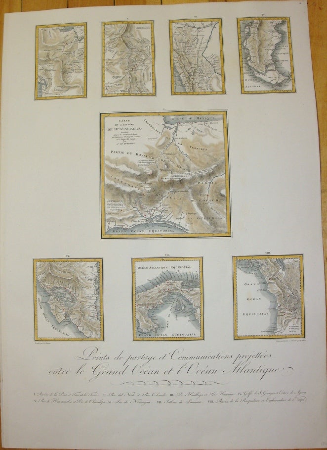
Points de partage et Communications projettees entre le Grand Ocean et L'Ocean Atlantique. / Carte De L'Isthme De Huasacualco / I. Riviere de la Paix et Tacoutche Tesse / II. Rio del Norte et Rio Colorado / III. Rio Huallaga et Rio Huanuco / IV. Golfe de S. Georges et Estero de Aysen / V. Rio de Huasacualco et Rio de Chimalapa / VI. Lac de Nicaragua / VII. Isthme de Panama / VIII. Ravin de la Raspadura et Embarcadero de Naipi.
Paris: c. 1810. Notes: These charts indicate potential communication points from the Pacific to the Atlantic across America. Published in the first French edition of "Political Essay on the Kingdom of New Spain" by Alexander de Humboldt., Size : 415x310 (mm), 16.34x12.20 (Inches), Coloring: Hand Colored, Category: Maps Central America Mexico; Maps Central America Countries; Maps South America Countries;. Excellent;. Item #M7000
Notes: These charts indicate potential communication points from the Pacific to the Atlantic across America. Published in the first French edition of "Political Essay on the Kingdom of New Spain" by Alexander de Humboldt., Size : 415x310 (mm), 16.34x12.20 (Inches), Coloring: Hand Colored, Category: Maps Canada West; Maps United States West Washington; Maps United States West New Mexico; Maps South America Peru; Maps South America Chile; Maps South America Argentina; Maps Central America Mexico; Maps South America Colombia;Maps Central America Countries;.
Price: $1,250.00