
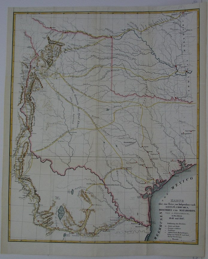
Karte uber eine Reise von Independence nach Santa Fe, Chihuahua, Monterrey und Matamoros von . . .
Braunschweig: 1850. Notes: "Frederick Adolphus Wislizenus, M.D., last heard of in 1840, headed for Chihuahua in 1846, and after being exiled for six months joined Doniphan's expedition on its trip home. In 1848, the Senate published his 'Memoir of a tour to Northern Mexico'. [...] 'A tour from Independence to Santa Fe, Chihuahua, Monterrey and Matamoros,' [...] is just what its title indicates. Many routes and caravan routes are shown in Texas, and the author's route is displayed in detail, along with the mountains he could see on either side of his long trail. (Wagner Camp 159; 30th Congress, 1st Session, Senate Misc. Doc. 26). A German edition, with the same maps (titles translated) was published at Braunschweig in 1850, the text having been translated by George M. Von Ross." (Wheat, Vol 3, 10)
"In 1848 Dr. A. Wislizenus, of St. Louis, published his 'Memoir of a tour to Northern Mexico, connected with Col. Doniphan's expedition, in 1846 and 1847,' with two maps, one of the journey and the other of the geological phenomena he had seen. The first is a map of considerable value, though it does not extend west of the New Mexico settlements nor north of the Arkansas River. A number of routes to New Mexico and across Texas are shown, and Doniphan's campaign is carefully followed from Independence, through New and Old Mexico to the camp of June 2nd, 1847, at Reynosa, near the mouth of the Rio Grande." (Wheat, Vol 3, 53-4), Size : 490x400 (mm), 19.25x15.75 (Inches), Coloring: Hand Colored in Outline, Reference: Wheat, Vol 3, 10; 53-4., Category: ; Maps United States South Texas. Very Good, lower left margin has been extended. Item #M6367
Notes: "Frederick Adolphus Wislizenus, M.D., last heard of in 1840, headed for Chihuahua in 1846, and after being exiled for six months joined Doniphan's expedition on its trip home. In 1848, the Senate published his 'Memoir of a tour to Northern Mexico'. [...] 'A tour from Independence to Santa Fe, Chihuahua, Monterrey and Matamoros,' [...] is just what its title indicates. Many routes and caravan routes are shown in Texas, and the author's route is displayed in detail, along with the mountains he could see on either side of his long trail. (Wagner Camp 159; 30th Congress, 1st Session, Senate Misc. Doc. 26). A German edition, with the same maps (titles translated) was published at Braunschweig in 1850, the text having been translated by George M. Von Ross." (Wheat, Vol 3, 10)
"In 1848 Dr. A. Wislizenus, of St. Louis, published his 'Memoir of a tour to Northern Mexico, connected with Col. Doniphan's expedition, in 1846 and 1847,' with two maps, one of the journey and the other of the geological phenomena he had seen. The first is a map of considerable value, though it does not extend west of the New Mexico settlements nor north of the Arkansas River. A number of routes to New Mexico and across Texas are shown, and Doniphan's campaign is carefully followed from Independence, through New and Old Mexico to the camp of June 2nd, 1847, at Reynosa, near the mouth of the Rio Grande." (Wheat, Vol 3, 53-4), Size : 490x400 (mm), 19.25x15.75 (Inches), Coloring: Hand Colored in Outline, Reference: Wheat, Vol 3, 10; 53-4., Category: ; Maps United States South Texas.
Price: $2,000.00