
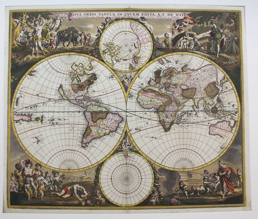
Nova Orbis Tabula, in Lucem.
Amsterdam: 1689. Notes: Second edition plate.
"De Wits's map is one of the most attractive of its time. The brilliant scenes in the corners combine images of the four seasons, the elements, and the signs of the zodiac in a well-balanced and naturalistic way. . . There was a second plate in c.1680 which can be distinguished by the appearance of 'Nova Guinea' and 'Quiri Regio' on the left-hand hemisphere." (Shirley)
Other changes in the second edition include the deletion of the strait of Anian present in the first edition (north of the island of California), greater detail in the North American continent (inclusion of Great Lakes and names around Hudson's Bay), and an updated north polar projection. The Great Lakes are based on Sanson's model., Size : 480x570 (mm), 18.875x22.375 (Inches), Coloring: Original Hand Coloring, Reference: Shirley 451, Category: ; Maps World. Very Good, some oxidation of the green pigment. Laid on acid free tissue paper for long term preservation. Item #M6325
Notes: Second edition plate.
"De Wits's map is one of the most attractive of its time. The brilliant scenes in the corners combine images of the four seasons, the elements, and the signs of the zodiac in a well-balanced and naturalistic way. . . There was a second plate in c.1680 which can be distinguished by the appearance of 'Nova Guinea' and 'Quiri Regio' on the left-hand hemisphere." (Shirley)
Other changes in the second edition include the deletion of the strait of Anian present in the first edition (north of the island of California), greater detail in the North American continent (inclusion of Great Lakes and names around Hudson's Bay), and an updated north polar projection. The Great Lakes are based on Sanson's model., Size : 480x570 (mm), 18.875x22.375 (Inches), Coloring: Original Hand Coloring, Reference: Shirley 451, Category: ; Maps World.
Price: $7,500.00