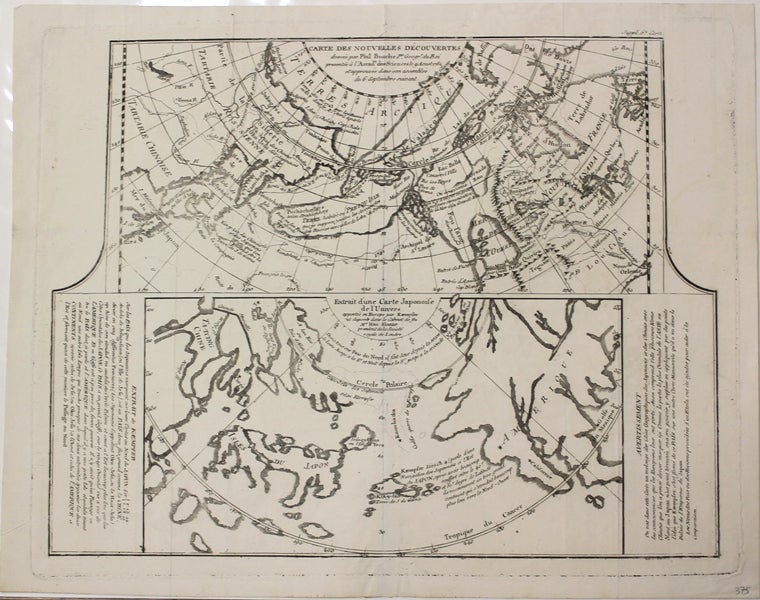
Carte des Nouvelles Decouvertes. . . / Extrait d'une Carte Japonoise de l'Univers
Paris: 1752. Notes: The map is divided into 2 sections
1752 - 1756 "These maps were included in Diderot's Enclyclopedie and thus were give wide circulation and much authority. This map is a simplified version of one made by Buache in 1752, the first to show Bearings two voyages of 1728 -30 and 1741-2 it was also the first to show the mythical Mer de l'Ouest in the vicinity of Vancouver, and idea subsequently much copied. Oddly if gives a Chinese name, Fou-Sang, to British Coloumbia. The lower map is a detail copied from a Japanese Map." (Portinaro and Knirsch pg. 249), Size : 295x380 (mm), 11.625x15 (Inches), Coloring: Black & White, Category: Maps Polar Arctic Regions;. Very Good. Item #M6265
Notes: The map is divided into 2 sections
1752 - 1756 "These maps were included in Diderot's Enclyclopedie and thus were give wide circulation and much authority. This map is a simplified version of one made by Buache in 1752, the first to show Bearings two voyages of 1728 -30 and 1741-2 it was also the first to show the mythical Mer de l'Ouest in the vicinity of Vancouver, and idea subsequently much copied. Oddly if gives a Chinese name, Fou-Sang, to British Coloumbia. The lower map is a detail copied from a Japanese Map." (Portinaro and Knirsch pg. 249), Size : 295x380 (mm), 11.625x15 (Inches), Coloring: Black & White, Category: ; Maps Polar Arctic Regions; Maps Polar Arctic Regions Alaska; Maps Asia Far East Japan; Maps Russia; Maps Canada Arctic.
Price: $375.00