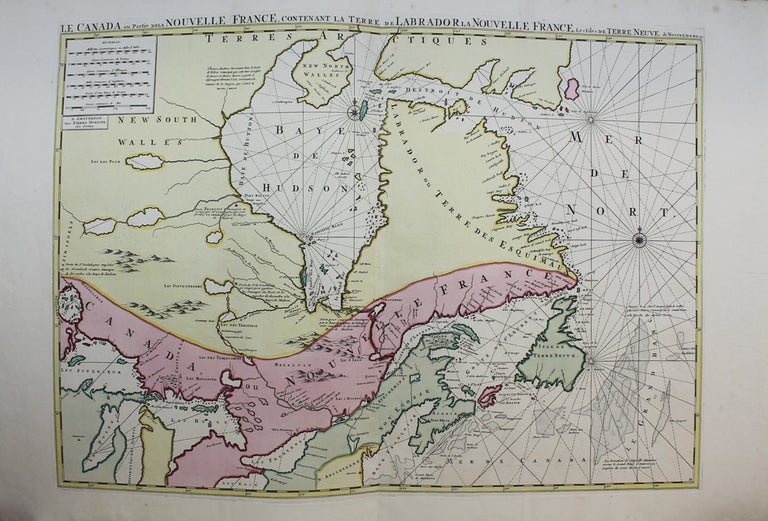
Le canada ou partie dela nouvelle France, contenant la Terre de Labrador la Nouvelle France, Les Isles de Terre Neuve, de Nostredame
Amsterdam: c.1696. Notes: A fine wide margin copy with striking original hand colouring. Scarce; first state. Large, "very striking map" (Kershaw) whose delineation of the Great Lakes is based on Jesuit reports via the Jaillot map. "In making this map, Mortier depended upon the work of Alexis Hubert Jaillot of Paris. .. [Jaillot's] map was copied not only by Pierre Mortier, but also by others. The care with which Jaillot worked can be seen in the proportions of Hudson Bay, which are superior to those in English maps of 1690 and even of 1746, although the English had occupied the Bay. … The map also shows the river route to Hudson Bay which had been pioneered by Paul Denis, … , and Father Charles Albanel in 1671. The Growing rivalry between the English and the French for the attentions of the Indians who supplied the furs is attested by notes on the map. On the left is a note indicating the trading post at St. Duluth, which was built to stop the Indians from trading in Hudson Bay […]. The maker and publisher of this map, Pierre Mortier, lived and worked in Amsterdam at the turn of the eighteenth century. Although not himself an innovator, Mortier produced some of the finest examples of the art of map-engraving in his copies of the work of such distinguished map-makers as Sanson, de Fer, Jaillot, and John Thornton. In his copies Mortier adhered closely to the originals but usually perfected them by the fineness of his engraving. [...] The Mortier copies are frequently so faithful to the original and so well done as engravings that they are often preferred to the original."
-Verner and Stuart-Stubbs, Size : 565x790 (mm), 22.25x31.125 (Inches), Coloring: Original Hand Coloring, Reference: Kershaw 176.1; Karpinski, p.117, Verner and Stuart-Stubbs p.40, Category: Maps Sea Chart; Maps Canada; Maps North America Great Lakes. Excellent. Item #M611
Notes: A fine wide margin copy with striking original hand colouring. Scarce; first state. Large, "very striking map" (Kershaw) whose delineation of the Great Lakes is based on Jesuit reports via the Jaillot map. "In making this map, Mortier depended upon the work of Alexis Hubert Jaillot of Paris. .. [Jaillot's] map was copied not only by Pierre Mortier, but also by others. The care with which Jaillot worked can be seen in the proportions of Hudson Bay, which are superior to those in English maps of 1690 and even of 1746, although the English had occupied the Bay. … The map also shows the river route to Hudson Bay which had been pioneered by Paul Denis, … , and Father Charles Albanel in 1671. The Growing rivalry between the English and the French for the attentions of the Indians who supplied the furs is attested by notes on the map. On the left is a note indicating the trading post at St. Duluth, which was built to stop the Indians from trading in Hudson Bay […]. The maker and publisher of this map, Pierre Mortier, lived and worked in Amsterdam at the turn of the eighteenth century. Although not himself an innovator, Mortier produced some of the finest examples of the art of map-engraving in his copies of the work of such distinguished map-makers as Sanson, de Fer, Jaillot, and John Thornton. In his copies Mortier adhered closely to the originals but usually perfected them by the fineness of his engraving. [...] The Mortier copies are frequently so faithful to the original and so well done as engravings that they are often preferred to the original."
-Verner and Stuart-Stubbs, Size : 565x790 (mm), 22.25x31.125 (Inches), Coloring: Original Hand Coloring, Reference: Kershaw 176.1; Karpinski, p.117, Verner and Stuart-Stubbs p.40, Category: Maps Sea Chart; Maps Canada; Maps North America Great Lakes.
Price: $2,750.00