
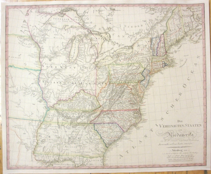
Die Vereinigten Staaten von Nordamerika
Nuremberg: Schneider and Weigel, 1812. Notes: A rare German map of the United States that was based on the maps by Arrowsmith and Lewis published in 1795 and 1796. Roads and Indian tribes are noted, in addition the Tennassee Government is shown. Due to Spanish claims at the time the state of Georgia has been extended to the Mississippi river. The future Minnesota territory is called Mosquito Land Shaft. The map was published by Schneider and Weigel in Nuremburg., Size : 535x660 (mm), 21x26 (Inches), Coloring: Original Outline Coloring, Reference: McCorkle 799.11, Category: Maps North America Great Lakes;Maps United States South;Maps United States East;. Excellent;. Item #M5367
Notes: A rare German map of the United States that was based on the maps by Arrowsmith and Lewis published in 1795 and 1796. Roads and Indian tribes are noted, in addition the Tennassee Government is shown. Due to Spanish claims at the time the state of Georgia has been extended to the Mississippi river. The future Minnesota territory is called Mosquito Land Shaft. The map was published by Schneider and Weigel in Nuremburg., Size : 535x660 (mm), 21x26 (Inches), Coloring: Original Outline Coloring, Reference: McCorkle 799.11, Category: Maps North America Great Lakes;Maps United States South;Maps United States East;.
Price: $2,200.00