
Carte Generale de Canada ; Terre de Labrador ou des Eskimaux Grand Espace de Terre.
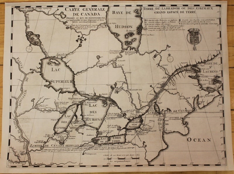
The Hague: 1705. Notes: Scarce first state of the map.
"This primary map of Canada emphasizes the importance of the river trading routes. . .it is the first map of Canada that was generally available to the public, and was on that defined, at least for the southern and eastern parts of the country the fur-trading routes." (Kershaw 289)
This very interesting map of the Great Lakes shows Canada and New England with numerous waterways. Lahontan appears to have used earlier works coupled with more recent data. Michigan is shown here with a narrow triangular shape in the north. There is good detail of the beaver-hunting grounds of the Native Indians; Lahontan's depiction of the interconnected lakes and rivers shows the trading in the region.
A number of forts and towns are identified, including Boston, Manhattan (Manate) but without Long Island, Montreal, Quebec (Kebek), and Chicago (Chegakou). Portages between rivers are marked with a Maltese cross and the Indian Villages that were destroyed by the Iroquois are marked by a shield with three dots. A dashed line extending across the map indicates the "limits of Canada per the French" and a note below indicates that this boundary also served as the route that various Indian tribes used to wage war with the Iroquois.
Louis Armand, Baron de Lahontan served ten years in the French military in Canada, was involved in the Indian Wars, and commanded several posts in the west. He traveled extensively in the Wisconsin and Minnesota region and the upper Mississippi Valley. Upon his return to Europe he wrote his enormously popular travelogue, Nouveaux Voyages de M. le Baron de Lahontan dans l'Amerique Septentrionale. In it he embellished his knowledge of the geography of the Great Lakes region, invented Indian tribes, and created several fictions, particularly the River Longue, which he claimed extended from the Mississippi River to the Rocky Mountains. Over twenty editions of his book were published between 1703 and 1741, including editions in French, English, Dutch and German. The immense popularity of the book resulted in his distorted cartography being accepted by several eminent cartographers who incorporated the "Lahontan" concepts into most 18th century maps.
Ref: Kershaw #290; Verner & Stuart-Stubbs #10; Heidenreich & Dahl (TMC 19) p. 4; McCorkle #703.3.
, Size : 420x555 (mm), 16.5x21.875 (Inches), Coloring: Black & White, Reference: Kershaw 290; Verner and Stuart-Stubbs 10; The Map House of London 22, Category: Maps Canada; Maps North America Great Lakes. Very good , backed on acid free tissue paper for long term preservation. Item #M4306
Notes: Scarce first state of the map.
"This primary map of Canada emphasizes the importance of the river trading routes. . .it is the first map of Canada that was generally available to the public, and was on that defined, at least for the southern and eastern parts of the country the fur-trading routes." (Kershaw 289)
This very interesting map of the Great Lakes shows Canada and New England with numerous waterways. Lahontan appears to have used earlier works coupled with more recent data. Michigan is shown here with a narrow triangular shape in the north. There is good detail of the beaver-hunting grounds of the Native Indians; Lahontan's depiction of the interconnected lakes and rivers shows the trading in the region.
A number of forts and towns are identified, including Boston, Manhattan (Manate) but without Long Island, Montreal, Quebec (Kebek), and Chicago (Chegakou). Portages between rivers are marked with a Maltese cross and the Indian Villages that were destroyed by the Iroquois are marked by a shield with three dots. A dashed line extending across the map indicates the "limits of Canada per the French" and a note below indicates that this boundary also served as the route that various Indian tribes used to wage war with the Iroquois.
Louis Armand, Baron de Lahontan served ten years in the French military in Canada, was involved in the Indian Wars, and commanded several posts in the west. He traveled extensively in the Wisconsin and Minnesota region and the upper Mississippi Valley. Upon his return to Europe he wrote his enormously popular travelogue, Nouveaux Voyages de M. le Baron de Lahontan dans l'Amerique Septentrionale. In it he embellished his knowledge of the geography of the Great Lakes region, invented Indian tribes, and created several fictions, particularly the River Longue, which he claimed extended from the Mississippi River to the Rocky Mountains. Over twenty editions of his book were published between 1703 and 1741, including editions in French, English, Dutch and German. The immense popularity of the book resulted in his distorted cartography being accepted by several eminent cartographers who incorporated the "Lahontan" concepts into most 18th century maps.
Ref: Kershaw #290; Verner & Stuart-Stubbs #10; Heidenreich & Dahl (TMC 19) p. 4; McCorkle #703.3.
, Size : 420x555 (mm), 16.5x21.875 (Inches), Coloring: Black & White, Reference: Kershaw 290; Verner and Stuart-Stubbs 10; The Map House of London 22, Category: Maps Canada; Maps North America Great Lakes.
Price: $6,500.00