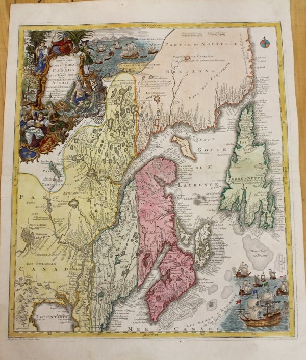
Partie orientale de la Nouvelle France ou du Canada avec l'isle de Terre - Neuve et de Nouvelle Escosse, Acadie et Nouv. Angleterre avec Fleuve St. Laurence
Augsburg: 1745. Notes: Second State. Very unusual elongated map of the East coast of Canada. A beautiful map of Northeastern Canada, including Nova Scotia, Labrador and Newfoundland. This is the second state of the map originally drawn by Seutter and engraved by Lotter, with Lotter’s imprint. The map's vertical format elongates the geography and distorts Newfoundland. The St. Lawrence River runs nearly north-south. It is very detailed, especially along the coastlines and rivers. Many place names, both European and Indian. At bottom right is a scene with several sailing ships. At top left is a huge decorative title cartouche featuring allegorical figures, Indian chiefs, explorers, mapmakers, a fleet of ships, fishermen and wildlife.
"The artwork and engraving are typical of the German school. Denied first-hand exploration information by the location of their country, the Germans, far from the sea, explore the world of fantasy with bold finesse, making imagery more imprtant than scientific fact. ... The whole surface is cluttered with illustrations. It is difficult to find another map on this scale with so many small, well-drawn scenes."
-Armstrong, Size : 585x499 (mm), 23x19.625 (Inches), Coloring: Original Hand Coloring, Reference: Kershaw #344; Moreland and Bannister, p. 90; Armstrong 28; Warkentin 1974; Skelton 1964 p. 258 and 272; BN du Q # 1155; Lemon 1987, Category: Maps Canada East; Maps United States New England; Maps Canada East Newfoundland;. Very Good. Item #M36
Notes: Second State. Very unusual elongated map of the East coast of Canada. A beautiful map of Northeastern Canada, including Nova Scotia, Labrador and Newfoundland. This is the second state of the map originally drawn by Seutter and engraved by Lotter, with Lotter’s imprint. The map's vertical format elongates the geography and distorts Newfoundland. The St. Lawrence River runs nearly north-south. It is very detailed, especially along the coastlines and rivers. Many place names, both European and Indian. At bottom right is a scene with several sailing ships. At top left is a huge decorative title cartouche featuring allegorical figures, Indian chiefs, explorers, mapmakers, a fleet of ships, fishermen and wildlife.
"The artwork and engraving are typical of the German school. Denied first-hand exploration information by the location of their country, the Germans, far from the sea, explore the world of fantasy with bold finesse, making imagery more imprtant than scientific fact. ... The whole surface is cluttered with illustrations. It is difficult to find another map on this scale with so many small, well-drawn scenes."
-Armstrong, Size : 585x499 (mm), 23x19.625 (Inches), Coloring: Original Hand Coloring, Reference: Kershaw #344; Moreland and Bannister, p. 90; Armstrong 28; Warkentin 1974; Skelton 1964 p. 258 and 272; BN du Q # 1155; Lemon 1987, Category: Maps Canada East; Maps United States New England; Maps Canada East Newfoundland;.
Price: $1,500.00