
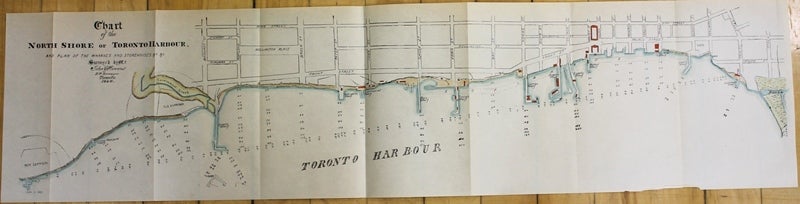
Chart of the North Shore of Toronto Harbour, and plan of the Wharves and Storehouses &c &c. Surveyed by Mr. John Howard DP. Surveyer Toronto. 1846.
Toronto: 1846 but 1890. Notes: Map of Toronto Harbour. , Size : 195x820 (mm), 7.68x32.28 (Inches), Coloring: Hand Colored, Category: Maps City Maps; Maps Canada Ontario South York Toronto;. Very Good. Item #M1158
Size : 195x820 (mm), 7.68x32.28 (Inches), Coloring: Hand Colored, Category: Maps City Maps; Maps Canada Ontario South York Toronto;.
Price: $475.00
See all items in
Maps
See all items by John Howard