
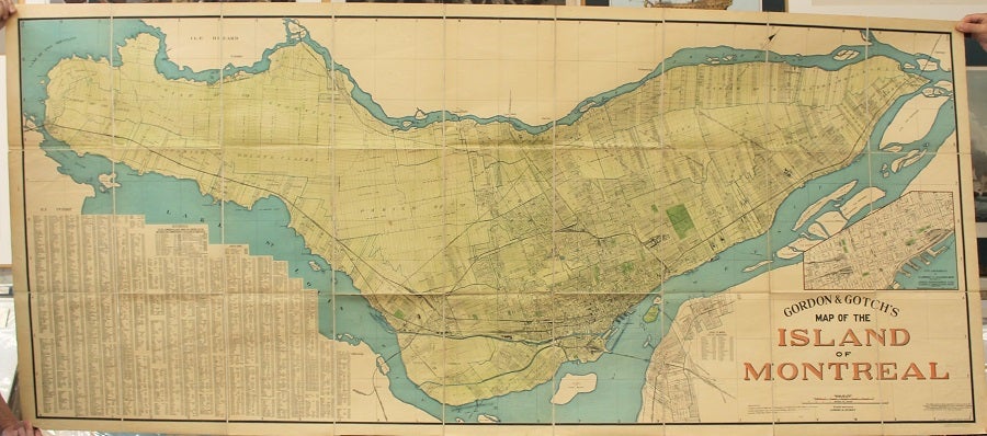
Gordon & Gotch's Map of the Island of Montreal.
Montreal: Gordon & Gotch, 1924. Notes: This Map is based on the coordination of actual surveys of all Railway Lines, the Georgian Bay Canal and Dom. Gov't Geodetic Triangulation. The boundaries of Cities, Towns and Villages have been obtained from the Revised Statutes of the Province of Quebec.
With an inset map: Enlargement of St.Lawrence and Ville-Marie Wards and Parts of Cremazie, Papineau, St.Andrew, St.Ann, St.George, St.James & St.Joseph Wards., Size : 950x2230 (mm), 37.40x87.80 (Inches), Coloring: Printed in Color with Some Hand Coloring, Category: Maps City Maps; Maps Canada East Quebec Montreal; Maps 20th Century Maps; Maps Folding Maps;. Very Good, backed on original linen. Item #M10753
Notes: This Map is based on the coordination of actual surveys of all Railway Lines, the Georgian Bay Canal and Dom. Gov't Geodetic Triangulation. The boundaries of Cities, Towns and Villages have been obtained from the Revised Statutes of the Province of Quebec.
With an inset map: Enlargement of St.Lawrence and Ville-Marie Wards and Parts of Cremazie, Papineau, St.Andrew, St.Ann, St.George, St.James & St.Joseph Wards., Size : 950x2230 (mm), 37.40x87.80 (Inches), Coloring: Printed in Color with Some Hand Coloring, Category: Maps City Maps; Maps Canada East Quebec Montreal; Maps 20th Century Maps; Maps Folding Maps;.
Price: $2,750.00