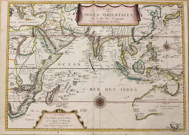
Carte des Indes Orientales Par P. Du Val Geographe Ordinaire du Roy.
Paris: c.1665. Notes: Very rare significant and first edition map published in 1665, from Duval's atlas, Cartes de Geographie les Plus Nouvelles depicting Indian Ocean, extending from Australia and South Africa to China and Asia Minor.
This is one of the earliest French maps to show the important 17th Century discoveries that occurred in Australia. It features the discoveries of Abel Tasman, derived from his voyages to Australia and New Zealand, from 1642 to 1644. Perry, states that Du Val's map is: "…one of the earliest French maps to depict Australia as defined by Tasman's two voyages, show[ing] the East Indian archipelagos of Indonesia and the Philippines and the entire area between the Cape of Good Hope and Japan and Australia, with Tasmania forming the southern limit in the east. The map also shows the earlier discoveries in Australia of Hartog, Cartensz and Nuyts."
India, Indochina and the Malaya Peninsula are based on the latest Dutch sea charts. The Indonesian Archipelago shape is somewhat correct, although New Guinea is still not right. China and Korea models are based on Thevenot.
, Size : 400x548 (mm), 15.75x21.57 (Inches), Coloring: Original Outline Coloring, Category: Maps Africa East; Maps Asia South East; Maps Pacific;. Very Good, Item #M10369
Notes: Very rare significant and first edition map published in 1665, from Duval's atlas, Cartes de Geographie les Plus Nouvelles depicting Indian Ocean, extending from Australia and South Africa to China and Asia Minor.
This is one of the earliest French maps to show the important 17th Century discoveries that occurred in Australia. It features the discoveries of Abel Tasman, derived from his voyages to Australia and New Zealand, from 1642 to 1644. Perry, states that Du Val's map is: "…one of the earliest French maps to depict Australia as defined by Tasman's two voyages, show[ing] the East Indian archipelagos of Indonesia and the Philippines and the entire area between the Cape of Good Hope and Japan and Australia, with Tasmania forming the southern limit in the east. The map also shows the earlier discoveries in Australia of Hartog, Cartensz and Nuyts."
India, Indochina and the Malaya Peninsula are based on the latest Dutch sea charts. The Indonesian Archipelago shape is somewhat correct, although New Guinea is still not right. China and Korea models are based on Thevenot.
, Size : 400x548 (mm), 15.75x21.57 (Inches), Coloring: Original Outline Coloring, Category: Maps Africa East; Maps Asia South East; Maps Oceania (Pacific) Australia;.
Price: $7,500.00