
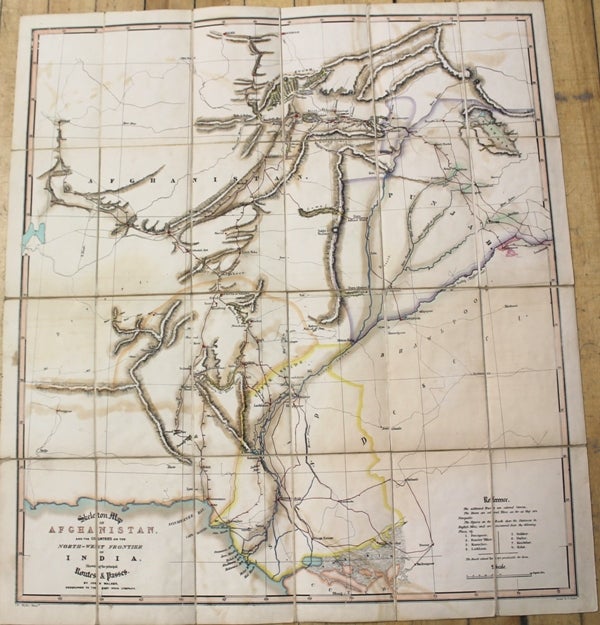
Skeleton Map of Afghanistan, and the Countries on the North-West Frontier of India, Shewing the Principal Routes & Passes.
London & India: James Wyld, 1848. Notes: Rare, First edition map of Afghanistan illustrating the 'Great Game' wherein colonial powers jostled for control of Central Asia in a series of conflicts. Published in the years following the First Anglo-Afghan War, the map depicts the region from Herat to Islamabad and Lahore, Pakistan and Firozpur (Ferozpoor), India and from Balkh and Kunduz (Koondooz), Afghanistan to the Kutch (Cutch) District in Gujarat, India.
There are only three examples held in institutional collections at the British Library, the Bibliothèque Nationale de France, and at Yale University., Size : 715x643 (mm), 28.15x25.31 (Inches), Coloring: Original Hand Coloring, Category: Maps Asia Central Afghanistan, Pakistan; Maps Folding Maps;. Very Good, folded map on original linen. Item #M10313
Notes: Rare, First edition map of Afghanistan illustrating the 'Great Game' wherein colonial powers jostled for control of Central Asia in a series of conflicts. Published in the years following the First Anglo-Afghan War, the map depicts the region from Herat to Islamabad and Lahore, Pakistan and Firozpur (Ferozpoor), India and from Balkh and Kunduz (Koondooz), Afghanistan to the Kutch (Cutch) District in Gujarat, India.
There are only three examples held in institutional collections at the British Library, the Bibliothèque Nationale de France, and at Yale University., Size : 715x643 (mm), 28.15x25.31 (Inches), Coloring: Original Hand Coloring, Category: Maps Asia Central Afghanistan, Pakistan; Maps Folding Maps;.
Price: $2,750.00