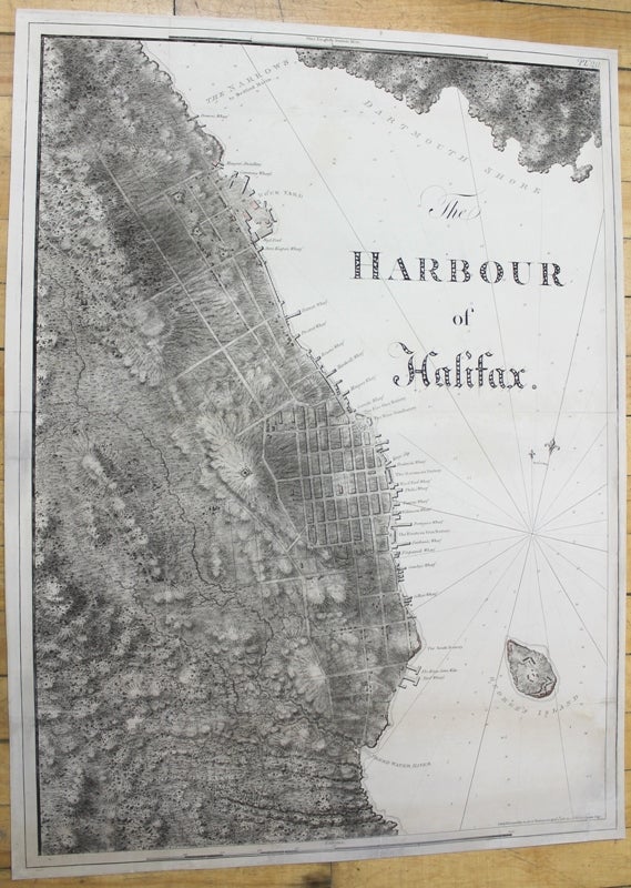
The Harbour of Halifax.
London: c.1781. Notes: scarce and superb sea chart constructed for the use of the British Navy shows The Harbour of Halifax, Nova Scotia, during the late 18th century.
Colonel Joseph Frederick Wallet DesBarres (1721 – 1824) was a hydrographer, cartographer, military engineer and landscape artist who served in the Seven Years War, in part, as the aide-de-camp to General James Wolfe. He also created the monumental four volume Atlantic Neptune, which was the most important collection of maps, charts and views of North America published in the eighteenth century. Finally, he was the Governor of Cape Breton Island and Prince Edward Island. , Size : 837x616 (mm), 32.95x24.25 (Inches), Coloring: Black & White, Category: Maps City Maps; Maps Canada East Nova Scotia;. Very good, few marginal tears expertly repaired; backed on acid free tissue paper for long term preservation. Item #M10024
Notes: scarce and superb sea chart constructed for the use of the British Navy shows The Harbour of Halifax, Nova Scotia, during the late 18th century.
Colonel Joseph Frederick Wallet DesBarres (1721 – 1824) was a hydrographer, cartographer, military engineer and landscape artist who served in the Seven Years War, in part, as the aide-de-camp to General James Wolfe. He also created the monumental four volume Atlantic Neptune, which was the most important collection of maps, charts and views of North America published in the eighteenth century. Finally, he was the Governor of Cape Breton Island and Prince Edward Island. , Size : 837x616 (mm), 32.95x24.25 (Inches), Coloring: Black & White, Category: Maps City Maps; Maps Canada East Nova Scotia;.
Price: $17,000.00