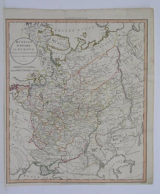
Russian Empire in Europe
London: 1811. Size : 463x395 (mm), 18.25x15.5 (Inches), Coloring: Original Hand Coloring, Category: Maps Russia. Size : 463x395 (mm), 18.25x15.5 (Inches), Coloring: Original Hand Coloring, Category: Maps Russia.
London: 1811. Size : 463x395 (mm), 18.25x15.5 (Inches), Coloring: Original Hand Coloring, Category: Maps Russia. Size : 463x395 (mm), 18.25x15.5 (Inches), Coloring: Original Hand Coloring, Category: Maps Russia.
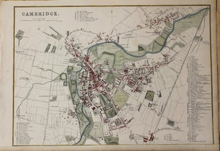
London: Day & Son Lithographers to the Queen, c.1860. Notes: Published in Weekly Dispatch Atlas., Size : 217x306 (mm), 8.54x12.05 (Inches), Coloring: Hand Colored, Category: Maps City Maps; Maps Europe United Kingdom England;. Notes: Published in Weekly Dispatch Atlas., Size : 217x306 (mm), 8.54x12.05 (Inches), Coloring: Hand Colored, Category: Maps.....
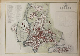
London: Day & Son Lithographers to the Queen, c.1860. Notes: Published in Weekly Dispatch Atlas., Size : 218x307 (mm), 8.58x12.09 (Inches), Coloring: Hand Colored, Category: Maps City Maps; Maps Europe United Kingdom England;. Notes: Published in Weekly Dispatch Atlas., Size : 218x307 (mm), 8.58x12.09 (Inches), Coloring: Hand Colored, Category: Maps.....
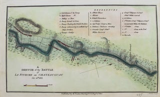
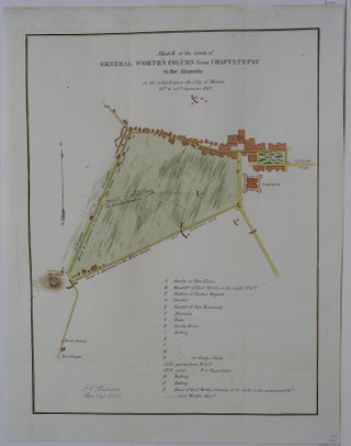
London: W. Faden, c.1815. Notes: A plan of the Battle of Chateauguay during the early 19th century, the War of 1812. The Battle of the Chateauguay was an engagement of the War of 1812. On 26 October 1813, a British force consisting of 1,630 regulars, volunteers and militia from Lower.....
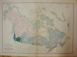
Toronto: 1909. Notes: An important map depicting the distribution of various Canadian Indian Tribes., Size : 386x537 (mm), 15.20x21.14 (Inches), Coloring: Printed in Color, Category: Maps Canada;. Notes: An important map depicting the distribution of various Canadian Indian Tribes., Size : 386x537 (mm), 15.20x21.14 (Inches), Coloring: Printed in Color, Category.....

Canada: Geological Survey of Canada, 1897. Notes: Nipissing District Ontario, and Pontiac county Quebec. (Lake Temiscaming Sheet), Size : 320x470 (mm), 12.625x18.5 (Inches), Coloring: Printed in Color, Category: Maps Geological; Maps Canada Ontario Central;. Notes: Nipissing District Ontario, and Pontiac county Quebec. (Lake Temiscaming Sheet), Size : 320x470 (mm), 12.625x18.5.....
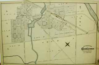
Toronto: Walker & Miles, c. 1877. Size : 431x644 (mm), 16.97x25.35 (Inches), Coloring: Hand Colored, Category: Maps City Maps; Maps Canada Ontario South Peel;. Size : 431x644 (mm), 16.97x25.35 (Inches), Coloring: Hand Colored, Category: Maps City Maps; Maps Canada Ontario South Peel;.
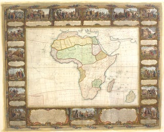
Paris: c.1800. Notes: Decorative wall map of Africa, first published in c.1750s and it was updated to 1800 by the great Nollin map makers family., Size : 1160x1482 (mm), 45.67x58.35 (Inches), Coloring: Hand Colored, Category: Maps Africa Continent; Maps Wall Maps;. Notes: Decorative wall map of Africa, first published in.....

London: John Arrowsmith, 1854. Size : 245x495 (mm), 9.625x19.5 (Inches), Coloring: Hand Colored, Category: Maps Folding Map;; Maps Military; Maps Europe Ukraine. Size : 245x495 (mm), 9.625x19.5 (Inches), Coloring: Hand Colored, Category: Maps Folding Map;; Maps Military; Maps Europe Ukraine.
Ottawa: 1915. Size : 385x537 (mm), Coloring: Hand Colored, Category: ; Maps Canada. Size : 385x537 (mm), Coloring: Hand Colored, Category: ; Maps Canada.
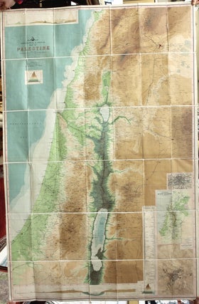
Edinburgh: John Bartholomew & Co., c.1900. Notes: With inset maps: "Plan of Jerusalem " and "Vegetation Map of Modern Palestine". Important political and geophysical map of Palestine. , Size : 1390x900 (mm), 54.72x35.43 (Inches), Coloring: Printed in Color, Category: Maps Wall Maps; Maps Asia Middle East Holy Land & Palestine;.....
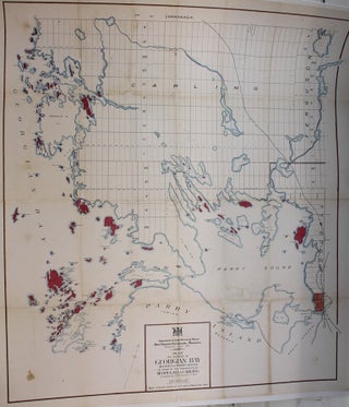
Toronto: Department of Lands, Forests & Mines, c.1911. Notes: A large-scale map of Georgian Bay, Ontario, during the early 20th century. The map shows railways, cities, geographical details, surveying information and it even shows which islands were for sale at the time (colored in red). , Size : 905x786 (mm).....
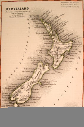
New York: 1856. Size : 165x108 (mm), 6.50x4.25 (Inches), Coloring: Hand Colored in Outline, Category: Maps Pacific;. Size : 165x108 (mm), 6.50x4.25 (Inches), Coloring: Hand Colored in Outline, Category: Maps Ocean Pacific;Maps Oceania (Pacific) New Zealand;.
U.S. U.S. War Department, 1847. Notes: From an important series depicting the Mexican-American War, Size : 360x272 (mm), 14.125x10.75 (Inches), Coloring: Hand Colored, Category: Maps Central America Mexico; Maps Military. Notes: From an important series depicting the Mexican-American War, Size : 360x272 (mm), 14.125x10.75 (Inches), Coloring: Hand Colored, Category: Maps.....
Ottawa: Bureau of Mines, 1904. Size : 470x680 (mm), 18.5x26.75 (Inches), Coloring: Hand Colored, Category: Maps Geological; Maps Canada Ontario Central; Maps Canada Ontario North;. Size : 470x680 (mm), 18.5x26.75 (Inches), Coloring: Hand Colored, Category: Maps Canada Ontario North Algoma; Maps Canada Ontario Central Nipissing; Maps Geological.
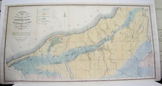
Philadelphia: P.S. Duval's Steam Lith Press, 1847. Size : 485x945 (mm), 19.125x37.125 (Inches), Coloring: Hand Colored, Category: Maps Geological; Maps North America Great Lakes;. Size : 485x945 (mm), 19.125x37.125 (Inches), Coloring: Hand Colored, Category: Maps Geological; Maps North America Great Lakes;.
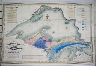
New York: J. Adkerman, 1847. Size : 645x990 (mm), 25.375x39 (Inches), Coloring: Original Hand Coloring, Category: Maps Geological; Maps North America Great Lakes;. Size : 645x990 (mm), 25.375x39 (Inches), Coloring: Original Hand Coloring, Category: Maps Geological; Maps North America Great Lakes;.
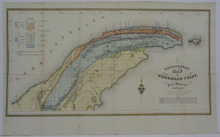
U.S.A. 1847. Size : 305x585 (mm), 12x23 (Inches), Coloring: Hand Colored, Category: Maps Geological; Maps United States Midwest (States);. Size : 305x585 (mm), 12x23 (Inches), Coloring: Hand Colored, Category: Maps United States Mid-West Michigan; Maps Geological.
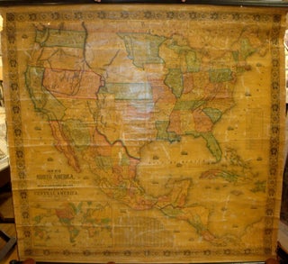
Baltimore: Jacob Monk, 1854. Notes: Inset map of the world sits beneath the title in the lower left corner. It is centred on the Americas and charts the course of Wilkes' circumnavigation of the globe in the 1840s. To its right sits an index of counties and towns. Above the.....
Paris: De Hondt, c.1755. Notes: In the late 16th century the important historical city of Monger was ruled by the Mughal Emperors. Shah Shuja, the second son of Mughal Emperor Shah Jahan, fled to Monger to escape persecution from his brother in the fight for power. After negotiations with his.....
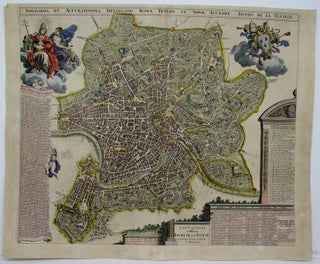
Amsterdam: 1689. Notes: (Stolen), Size : 495x590 (mm), 19.5x23.25 (Inches), Coloring: Hand Colored, Category: Maps City Maps; Maps Europe Italy Rome. Notes: (Stolen), Size : 495x590 (mm), 19.5x23.25 (Inches), Coloring: Hand Colored, Category: Maps City Maps; Maps Europe Italy Rome.
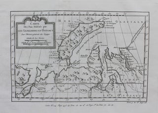
Paris: c. 1754. Notes: A detailed map of Siberia during the mid 18th century. The map extends from the White and Caspian Seas in the west to Irkuckoi Province, Jakutky on the Lena River and regions to the east. Jacques Nicolas Bellin (1703 – 1772) was a French hydrographer, geographer.....
Paris: c.1757. Notes: A detailed map of Manchuria and the eastern Tartary region during the mid 18th century. Jacques Nicolas Bellin (1703 – 1772) was a French hydrographer, geographer, and member of the French intellectual group called the philosophes. He was hydrographer of France's hydrographic office, member of the Académie.....
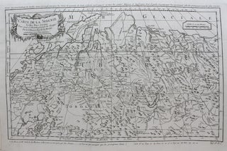
Paris: c. 1757. Notes: A detailed map of Novaya Zemlya and the northern shores of Russia during the mid 18th century. Jacques Nicolas Bellin (1703 – 1772) was a French hydrographer, geographer, and member of the French intellectual group called the philosophes. He was hydrographer of France's hydrographic office, member.....
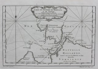
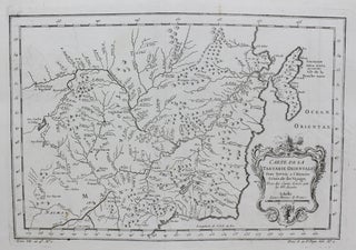
Paris: c. 1764. Notes: A regional map of the Arctic Sea, in particular the Strait of Waeigats, during the mid 18th century. Jacques Nicolas Bellin (1703 – 1772) was a French hydrographer, geographer, and member of the French intellectual group called the philosophes. He was hydrographer of France's hydrographic office.....