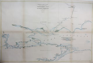
Geological Survey of Canada / Topographical Plan of Part of Lake Nipissing and Sturgeon River / Sheet 8
Montreal: Geological Survey of Canada, c.1856. Notes: This map depicts the western half of Lake Nipissing, its arms and also the mouth of the Sturgeon river on the north shore, and the source of the French River from the southern arm., Size : 555x855 (mm), 21.85x33.66 (Inches), Coloring: Hand Colored.....