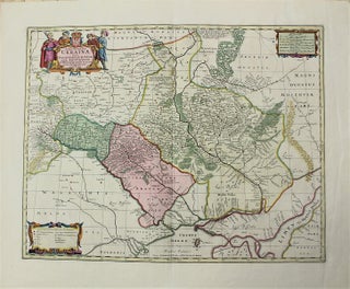
Typus Generalis Ukrainae sive Palatinatuum Podoliae Kioviensis et Braczlaviensis terras nova delineatione exhibens.
Amsterdam: c.1690. Size : 425x541 (mm), 16.73x21.30 (Inches), Coloring: Original Hand Coloring, Category: Maps Europe Ukraine;.
Amsterdam: Peter Schenk, c.1696; c.1717. Notes: The left sheet is a first state map, while the right sheet is a third state map. (Philip Burden, 439). "This beautiful map . . . is probably the most detailed delineation of the Coastline from the Carolinas to Labrador drawn in the 17th.....
Amsterdam: c. 1700. Notes: Gorgeously detailed map of the Egypt-Sinai peninsula area, and a decorated cartouche in the bottom right corner depicting several men and women dressed in Middle Eastern garb, several animals and plants, devices and the Pyramids in the background., Size : 405x498 (mm), 15.94x19.61 (Inches), Coloring: Original.....
Amsterdam: c.1710. Notes: A beautiful map of the West Indies with wide margins., Size : 408x522 (mm), 16.06x20.55 (Inches), Coloring: Original Hand Coloring, Category: Maps United States South Florida; Maps West Indies Cuba & Bahamas; Maps West Indies Dominican Republic / Haiti & Puerto Rico;. Notes: A beautiful map of.....