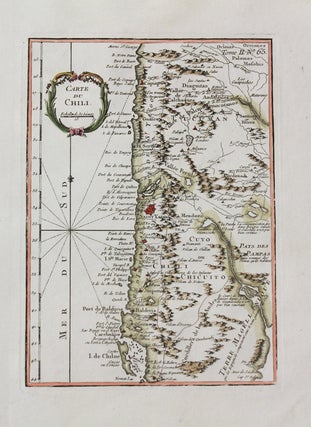
Carte Du Chili.
Paris: 1762-1764. Size : 249x178 (mm), 9.80x7.01 (Inches), Coloring: Hand Colored, Category: Maps South America Countries;. Size : 249x178 (mm), 9.80x7.01 (Inches), Coloring: Hand Colored, Category: Maps South America Chile;.
Paris: 1762-1764. Size : 249x178 (mm), 9.80x7.01 (Inches), Coloring: Hand Colored, Category: Maps South America Countries;. Size : 249x178 (mm), 9.80x7.01 (Inches), Coloring: Hand Colored, Category: Maps South America Chile;.
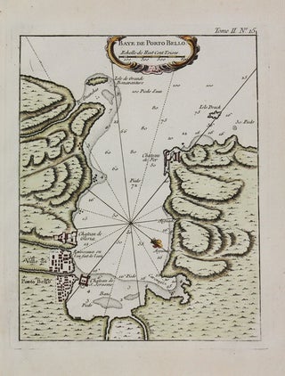
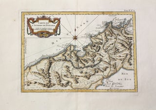
Paris: 1762-1764. Notes: Map of of Portobello (Panama)., Size : 225x180 (mm), 8.86x7.09 (Inches), Coloring: Hand Colored, Category: Maps Central America Countries;.
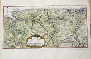
Paris: 1762-1764. Notes: Map showing the Dutch colony of Suriname surrounding the Suriname and Commewijne river systems. , Size : 226x428 (mm), 8.90x16.85 (Inches), Coloring: Hand Colored, Category: Maps South America Countries;. Notes: Map showing the Dutch colony of Suriname surrounding the Suriname and Commewijne river systems. , Size...
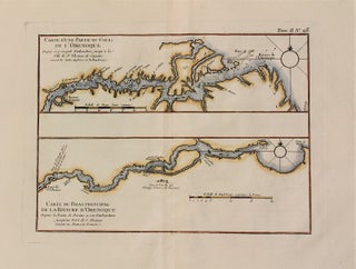
Paris: 1762-1764. Notes: Map of the course of Orenoque river. The Orinoco is one of the longest rivers in South America, Size : 235x315 (mm), 9.25x12.40 (Inches), Coloring: Hand Colored, Category: Maps South America Countries;.
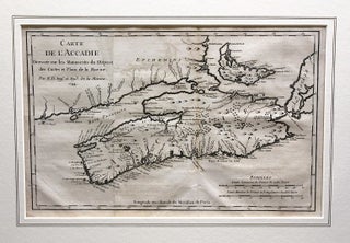
Paris: 1744. Notes: Map of Acadia by Jacques-Nicolas Bellin (1703-1772), French cartographer. Acadia was a colony of New France in northeastern North America which included parts of what are now the Maritime provinces, the Gaspe Peninsula and Maine to the Kennebec River., Size : 210x326 (mm), 8.27x12.83 (Inches), Coloring: Black.....
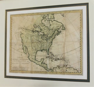
Paris: 1743. Notes: Important map of North America showing definitive and highly direct water route from Lake Superior to the Pacific Ocean [River of the West], finely framed., Size : 278x350 (mm), 10.94x13.78 (Inches), Coloring: Hand Colored, Category: Maps North America; Maps Central America Countries;.
Paris: 1762-1764. Notes: Map of Surinam., Size : 222x173 (mm), 8.74x6.81 (Inches), Coloring: Hand Colored, Category: Maps South America Countries;.
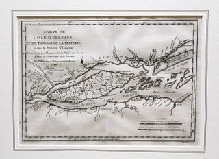
Paris: 1744. Notes: Map showing the Ile d'Orleans in St. Lawrence River by J. N. Bellin (1703-1772)., Size : 202x285 (mm), 7.95x11.22 (Inches), Coloring: Black & White, Category: Maps Canada East Quebec St. Lawrence River;.
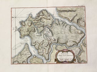
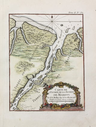
Paris: 1762-1764. Notes: Map of the Cayenne region, the capital of French Guiana, on the northeast coast of South America., Size : 256x333 (mm), 10.08x13.11 (Inches), Coloring: Hand Colored, Category: Maps South America Countries;.
Paris: 1762-1764. Notes: Rare map of the Isthmus of Panama., Size : 230x320 (mm), 9.06x12.60 (Inches), Coloring: Hand Colored, Category: Maps Central America Countries;. Notes: Rare map of the Isthmus of Panama., Size : 230x320 (mm), 9.06x12.60 (Inches), Coloring: Hand Colored, Category: Maps Central America Countries;.
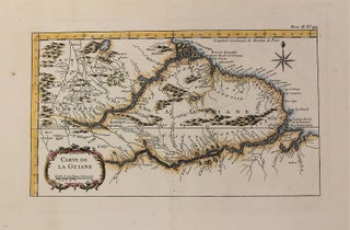
Paris: 1762-1764. Notes: Map showing Guyana region in South America., Size : 228x360 (mm), 8.98x14.17 (Inches), Coloring: Hand Colored, Category: Maps South America Countries;.
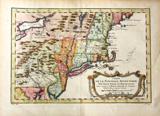
Paris: c.1757. Notes: Map of Northeast USA by Jacques-Nicolas Bellin (1703-1772), French cartographer. , Size : 216x311 (mm), 8.50x12.24 (Inches), Coloring: Hand Colored, Category: Maps United States New England (States);.

Paris: 1760. Size : 197x296 (mm), 7.75x11.625 (Inches), Coloring: Hand Colored, Category: Maps South America Countries;. Size : 197x296 (mm), 7.75x11.625 (Inches), Coloring: Hand Colored, Category: Maps South America Uruguay; Maps South America Argentina.
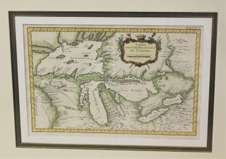
Paris: 1764. Notes: Map of the Great Lakes by renowned French cartographer Bellin, finely framed and beautifully hand coloured., Size : 214x329 (mm), 8.43x12.95 (Inches), Coloring: Hand Colored, Category: Maps North America Great Lakes;.
Paris: 1762-1764. Notes: Map of the Salvation Islands (French Guyana)., Size : 230x185 (mm), 9.06x7.28 (Inches), Coloring: Hand Colored, Category: Maps South America Countries;.
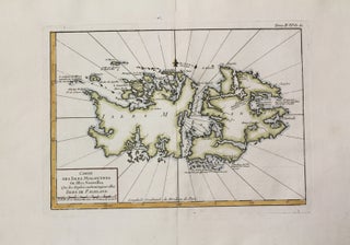
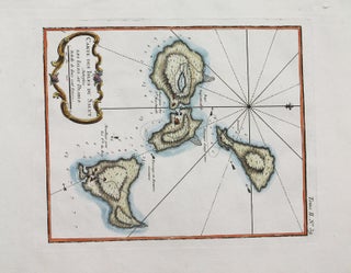
Paris: 1762-1764. Notes: Map of The Falkland Islands (Islas Malvinas) a remote South Atlantic archipelago., Size : 225x317 (mm), 8.86x12.48 (Inches), Coloring: Hand Colored, Category: Maps Ocean Atlantic;.
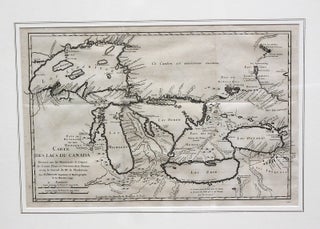
Paris: Hydrographe de la Marine, 1744. Notes: Important First edition of this map of the Great Lakes. It was published in " Histoire et Description Generale de la Nouvelle France". "This map, by the famous French map and chartmaker Jacques Nicolas Bellin, was published in 1744 in Fr Oierre Francois-Xavier.....
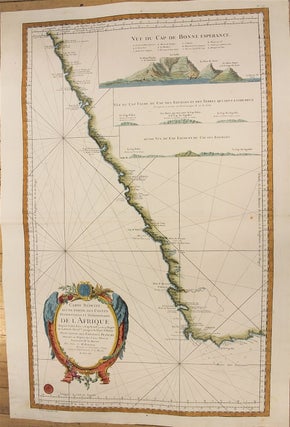
Paris: 1765. Notes: Map showing west part of South Africa, also has View of Cape of Good Hope., Size : 922x580 (mm), 36.30x22.83 (Inches), Coloring: Hand Colored, Category: Maps Africa South;.
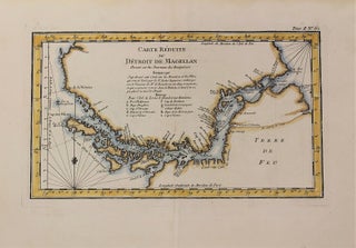
Paris: 1762-1764. Notes: Map of the Straits of Magellan. The Strait of Magellan is a sea route in southern Chile separating mainland South America to the north and Tierra del Fuego to the south. The strait is considered the most important natural passage between the Atlantic and Pacific oceans. It.....
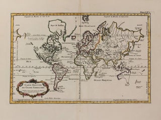
Paris: 1762-1764. Notes: World map by Jacques Nicolas Bellin, renowned French cartographer., Size : 226x360 (mm), 8.90x14.17 (Inches), Coloring: Hand Colored, Category: Maps World;.
Paris: 1762-1764. Notes: Map Showing mainly Ecuador., Size : 252x375 (mm), 9.92x14.76 (Inches), Coloring: Hand Colored, Category: Maps South America Countries;. Notes: Map Showing mainly Ecuador., Size : 252x375 (mm), 9.92x14.76 (Inches), Coloring: Hand Colored, Category: Maps South America Peru; Maps South America Ecuador;.
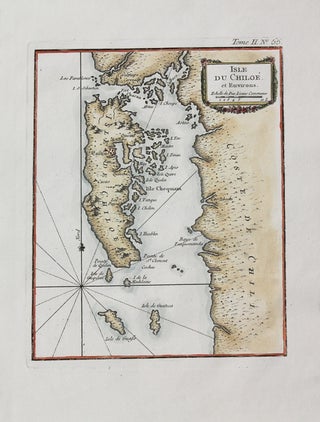
Paris: 1762-1764. Size : 228x180 (mm), 8.98x7.09 (Inches), Coloring: Hand Colored, Category: Maps South America Countries;.
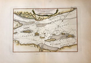
Paris: c.1764. Notes: Map of St. Lawrence River showing a number of small islands to the northeast of Ile d'Orleans and Quebec City by Jacques Nicolas Bellin, renowned French cartographer., Size : 226x332 (mm), 8.90x13.07 (Inches), Coloring: Hand Colored, Category: Maps Canada East Quebec St. Lawrence River;.
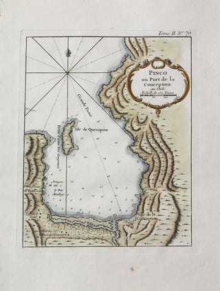
Paris: 1762-1764. Size : 225x180 (mm), 8.86x7.09 (Inches), Coloring: Hand Colored, Category: Maps South America Countries;.
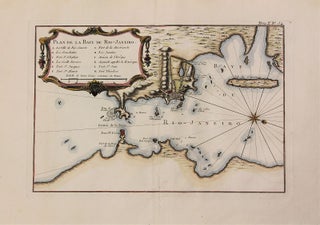
Paris: 1762-1764. Notes: Map showing the bay of Rio De Janeiro., Size : 225x334 (mm), 8.86x13.15 (Inches), Coloring: Hand Colored, Category: Maps South America Countries;.