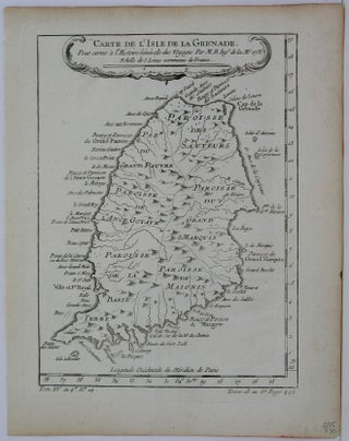
Carte de I'Isle de la Grenade
Paris: 1758. Size : 225x170 (mm), 8.875x6.75 (Inches), Coloring: Black & White, Category: ; Maps West Indies Whole. Size : 225x170 (mm), 8.875x6.75 (Inches), Coloring: Black & White, Category: ; Maps West Indies Whole.
Paris: 1758. Size : 225x170 (mm), 8.875x6.75 (Inches), Coloring: Black & White, Category: ; Maps West Indies Whole. Size : 225x170 (mm), 8.875x6.75 (Inches), Coloring: Black & White, Category: ; Maps West Indies Whole.
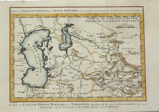
Amsterdam: 1749. Size : 210x300 (mm), 8.25x11.75 (Inches), Coloring: Hand Colored, Category: ; Maps Asia Central Turkmenistan, Uzbekistan, Tajikistan, Kyrgyzstan, Kazakhstan. Size : 210x300 (mm), 8.25x11.75 (Inches), Coloring: Hand Colored, Category: ; Maps Asia Central Turkmenistan, Uzbekistan, Tajikistan, Kyrgyzstan, Kazakhstan.
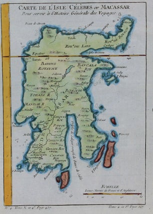
Paris: c.1760. Size : 210x145 (mm), 8.27x5.71 (Inches), Coloring: Hand Colored, Category: Maps Asia South East Indonesia & Papua New Guinea;. Size : 210x145 (mm), 8.27x5.71 (Inches), Coloring: Hand Colored, Category: Maps Asia South East Indonesia & Papua New Guinea;.
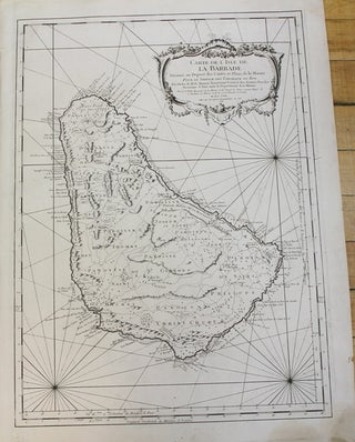
Paris: 1758. Size : 560x405 (mm), 22.05x15.94 (Inches), Coloring: Black & White, Category: Maps West Indies Other Islands;. Size : 560x405 (mm), 22.05x15.94 (Inches), Coloring: Black & White, Category: Maps West Indies Barbados;.
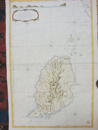
Paris: Depost La Marine, 1760. Size : 905x600 (mm), 35.63x23.62 (Inches), Coloring: Hand Colored, Category: Maps West Indies Other Islands;. Size : 905x600 (mm), 35.63x23.62 (Inches), Coloring: Hand Colored, Category: Maps West Indies Grenada;.
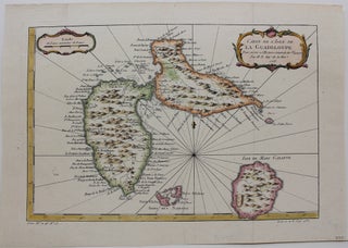
Paris: 1758. Size : 210x310 (mm), 8.25x12.25 (Inches), Coloring: Hand Colored, Category: Maps West Indies Other Islands;. Size : 210x310 (mm), 8.25x12.25 (Inches), Coloring: Hand Colored, Category: ; Maps West Indies Guadeloupe.
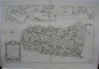
Paris: Ministre de la Marine, 1763. Notes: Excellent large scale map of St. Christopher, by the prominent 18th century French cartographer Bellin. Title is within a large decorative cartouche located on the lower left. With three large inset maps of Port du Carenage, Plan du Cul de Sac des Roseaux.....

Paris: 1763. Notes: An attractive map with a crisp and strong impression. A large cartouch appears on the lower left with partial origianl hand colouring. With and inset of the southern part of Newfoundland in the upper left., Size : 580x890 (mm), 22.875x35 (Inches), Coloring: Black & White, Category: Maps.....
Paris: 1744. Size : 245x380 (mm), 9.625x15 (Inches), Coloring: Black & White, Category: ; Maps Canada; Maps Ocean Atlantic; Maps United States. Size : 245x380 (mm), 9.625x15 (Inches), Coloring: Black & White, Category: ; Maps Canada; Maps Ocean Atlantic; Maps United States.
Paris: 1757. Notes: Published in "Allegmeine Historie der Reisen zu Wasser und zu Lande", Size : 210x305 (mm), 8.25x12 (Inches), Coloring: Hand Colored, Category: Maps United States East (States);. Notes: Published in "Allegmeine Historie der Reisen zu Wasser und zu Lande", Size : 210x305 (mm), 8.25x12 (Inches), Coloring: Hand Colored.....
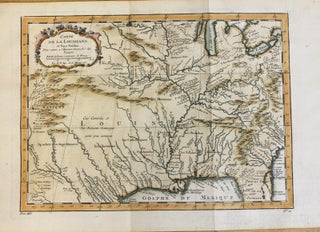
Paris: Departement de la Marine, 1755. Notes: Bellin in doing this map attempted to portray the territories of the Spanish, French and British along the eastern coast of North America. The Appalachian mountains form the western boarder of the British Colonies. This map was based on Delisle’s map of 1718.....
Paris: 1757. Size : 220x305 (mm), 8.625x12 (Inches), Coloring: Hand Colored, Category: ; Maps United States South Texas; Maps United States South Louisiana. Size : 220x305 (mm), 8.625x12 (Inches), Coloring: Hand Colored, Category: ; Maps United States South Texas; Maps United States South Louisiana.
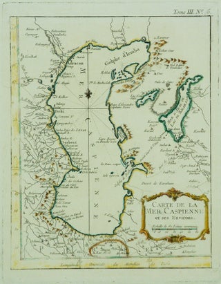
Paris: 1760. Notes: A map of Caspian Sea and surrounding countries of Iran, Azerbaijan, Turkmenistan. , Size : 235x183 (mm), 9.25x7.20 (Inches), Coloring: Original Outline Coloring, Category: Maps Asia Middle East;. Notes: A map of Caspian Sea and surrounding countries of Iran, Azerbaijan, Turkmenistan. , Size : 235x183 (mm), 9.25x7.20.....
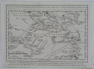
Amsterdam: 1748. Size : 240x320 (mm), 9.5x12.625 (Inches), Coloring: Black & White, Category: ; Maps Asia Central Turkmenistan, Uzbekistan, Tajikistan, Kyrgyzstan, Kazakhstan. Size : 240x320 (mm), 9.5x12.625 (Inches), Coloring: Black & White, Category: ; Maps Asia Central Turkmenistan, Uzbekistan, Tajikistan, Kyrgyzstan, Kazakhstan.
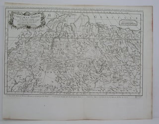
Paris: 1750. Size : 305x475 (mm), 12x18.75 (Inches), Coloring: Black & White, Category: Maps Russia. Size : 305x475 (mm), 12x18.75 (Inches), Coloring: Black & White, Category: Maps Russia.
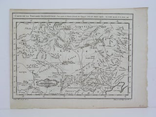
Paris: 1749. Size : 240x322 (mm), 9.5x12.625 (Inches), Coloring: Black & White, Category: Maps Russia. Size : 240x322 (mm), 9.5x12.625 (Inches), Coloring: Black & White, Category: Maps Russia.
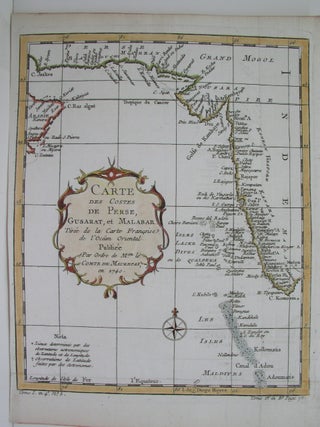
Paris: 1740. Size : 259x209 (mm), 10.25x8.25 (Inches), Coloring: Hand Colored, Category: Maps Asia Central India & Sri Lanka / Ceylon;. Size : 259x209 (mm), 10.25x8.25 (Inches), Coloring: Hand Colored, Category: Maps Asia Central India;.
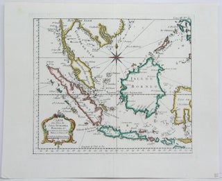
Paris: 1744. Size : 255x300 (mm), 10x11.75 (Inches), Coloring: Hand Colored in Outline, Category: ; Maps Asia South East Indonesia & Papua New Guinea; Maps Asia South East Malaysia & Singapore. Size : 255x300 (mm), 10x11.75 (Inches), Coloring: Hand Colored in Outline, Category: ; Maps Asia South East Indonesia &.....
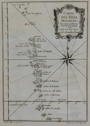
Paris: 1750. Notes: Maldives is located in the Indian Ocean South of India., Size : 220x155 (mm), 8.66x6.10 (Inches), Coloring: Black & White, Category: Maps Ocean Indian;. Notes: Maldives is located in the Indian Ocean South of India., Size : 220x155 (mm), 8.66x6.10 (Inches), Coloring: Black & White, Category: Maps.....
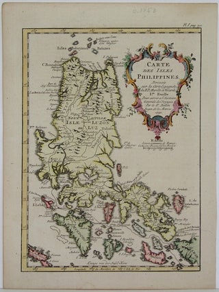
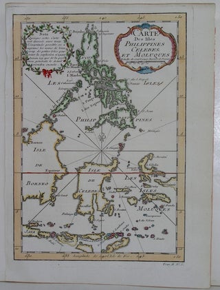
Paris: 1752. Size : 206x153 (mm), 8.125x6 (Inches), Coloring: Hand Colored, Category: ; Maps Asia South East Philippines. Size : 206x153 (mm), 8.125x6 (Inches), Coloring: Hand Colored, Category: ; Maps Asia South East Philippines.
Paris: 1744. Size : 235x165 (mm), 9.25x6.5 (Inches), Coloring: Hand Colored in Outline, Category: ; Maps Asia South East Indonesia & Papua New Guinea; Maps Asia South East Philippines. Size : 235x165 (mm), 9.25x6.5 (Inches), Coloring: Hand Colored in Outline, Category: ; Maps Asia South East Indonesia & Papua New.....
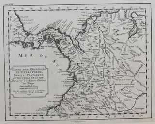
Paris: c. 1756. Size : 200x260 (mm), 7.875x10.25 (Inches), Coloring: Black & White, Category: Maps Central America Countries; Maps South America Countries;. Size : 200x260 (mm), 7.875x10.25 (Inches), Coloring: Black & White, Category: Maps South America Colombia;Maps Central America Countries;.
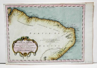
Paris: 1757. Size : 252x336 (mm), 9.875x13.25 (Inches), Coloring: Hand Colored, Category: Maps South America Countries;. Size : 252x336 (mm), 9.875x13.25 (Inches), Coloring: Hand Colored, Category: Maps South America Brazil.
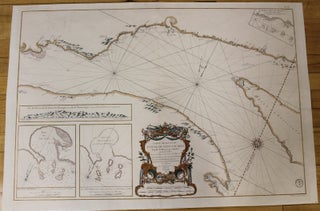
Paris: Depot de la Marine, 1761. Notes: This is the second state of the map according to Kershaw. There are two insets in the lower left., Size : 550x855 (mm), 21.625x33.625 (Inches), Coloring: Original Hand Coloring, Reference: Kershaw 656, Category: ; Maps Canada East Quebec St. Lawrence River. Notes: This.....
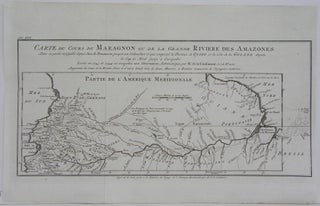
Paris: 1748. Size : 170x375 (mm), 6.75x14.75 (Inches), Coloring: Black & White, Category: Maps South America Countries;. Size : 170x375 (mm), 6.75x14.75 (Inches), Coloring: Black & White, Category: Maps South America Peru; Maps South America Brazil.