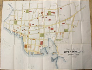
Map of the Lower Part of the City of Honolulu, and the Harbor Front.
USA: 1893. Notes: Map of downtown Honolulu, during the independent Hawaiian Kingdom era done by Albert B. Loebenstein, an American civil engineer and surveyor., Size : 595x770 (mm), 23.43x30.31 (Inches), Coloring: Hand Colored, Category: Maps City Maps; Maps United States West Hawaii;. Notes: Map of downtown Honolulu, during the independent.....