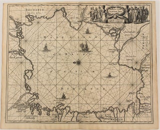
Paskaert Vande Caspise Zee.
Amsterdam: c.1670. Notes: Sea chart of the Caspian Sea., Size : 295x358 (mm), 11.61x14.09 (Inches), Coloring: Black & White, Category: Maps Russia; Maps Asia Middle East Iran, Iraq;.
Amsterdam: c.1670. Notes: Sea chart of the Caspian Sea., Size : 295x358 (mm), 11.61x14.09 (Inches), Coloring: Black & White, Category: Maps Russia; Maps Asia Middle East Iran, Iraq;.
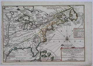
Paris: 1705. Notes: This decorative map focuses on the French possessions in North America. The treatment of French Florida is intriguing. The map shows the United States of America and parts of Southern Canada East of the Mississippi river. "Territorial expansion of New France had reached the Mississipi River with.....
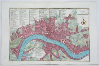
Paris: 1705. Size : 230x340 (mm), 9x13.375 (Inches), Coloring: Hand Colored, Category: Maps City Maps; Maps Europe United Kingdom England London. Size : 230x340 (mm), 9x13.375 (Inches), Coloring: Hand Colored, Category: Maps City Maps; Maps Europe United Kingdom England London.
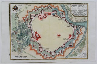
Paris: 1705. Size : 245x340 (mm), 9.625x13.375 (Inches), Coloring: Hand Colored, Category: Maps City Maps; Maps Europe Austria. Size : 245x340 (mm), 9.625x13.375 (Inches), Coloring: Hand Colored, Category: Maps City Maps; Maps Europe Austria.
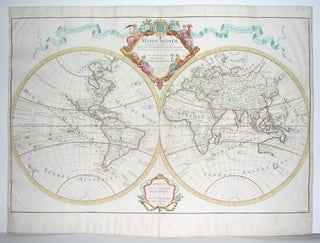
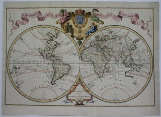
Paris: 1700. Size : 438x665 (mm), 17.25x26.125 (Inches), Coloring: Original Outline Coloring, Category: Maps World. Size : 438x665 (mm), 17.25x26.125 (Inches), Coloring: Original Outline Coloring, Category: Maps World.
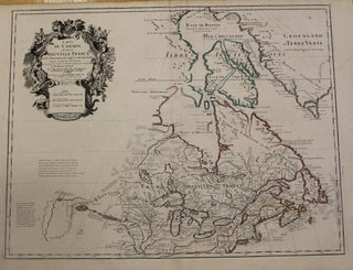
Paris: 1703 but 1718. Notes: Fifth State. Scarce. "Del'Isle's map of Canada is one of the most outstanding maps of Canada of the 17th and early 18th centuries. Typical of all of his work, the information that went into his map of Canada was the result of careful and painstaking.....
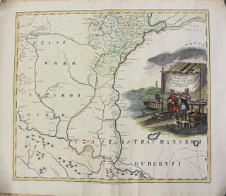
St. Petersburg: Entworffen bey der Kayserl. Academie der Wissenschaften, 1745. Notes: Map showing Volga River Region in Russia. L'Isle, Joseph Nicolas de, 1688-1768. Kirilov, Ivan Kirillovich, 1689-1737. The map has a large decorative cartouche depicting fishermen across Volga river., Size : 498x560 (mm), 19.61x22.05 (Inches), Coloring: Original Hand Coloring, Category.....
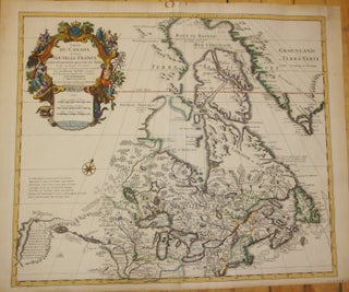
Amsterdam: Covens & Mortier, 1730. Notes: Second state. "De L'Isle's careful research resulted in the first mpa of Canada to present the whole of the Great Lakes correctly. In addition, the postion of the lakes relative to Hudson Bay is also correct, and the Avalon Peninsula is shown much more.....
Amsterdam: 1730. Size : 445x685 (mm), 17.5x27 (Inches), Coloring: Hand Colored in Outline, Category: Maps World. Size : 445x685 (mm), 17.5x27 (Inches), Coloring: Hand Colored in Outline, Category: Maps World.
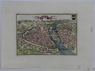
Amsterdam: 1702. Size : 125x180 (mm), 4.875x7.125 (Inches), Coloring: Hand Colored, Category: Maps City Maps; Maps Europe France Paris. Size : 125x180 (mm), 4.875x7.125 (Inches), Coloring: Hand Colored, Category: Maps City Maps; Maps Europe France Paris.
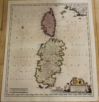
Amsterdam: 1688. Size : 570x485 (mm), 22.375x19.125 (Inches), Coloring: Original Hand Coloring, Category: Maps Mediterranean Islands;. Size : 570x485 (mm), 22.375x19.125 (Inches), Coloring: Original Hand Coloring, Category: Maps Mediterranean Islands;.

Amsterdam: c. 1680. Notes: The title cartouche in the lower right corner depicts putti and mermaids around the Corsican and Sardinian coats of arms., Size : 567x481 (mm), 22.32x18.94 (Inches), Coloring: Original Hand Coloring, Category: Maps Mediterranean Islands;. Notes: The title cartouche in the lower right corner depicts putti and.....
Paris: 1795. Notes: Price for the pair. Two decorative and important maps of Russia based on Vaugondy's Russian Atlas on Russia., Size : 475x1210 (mm), 18.75x47.625 (Inches), Coloring: Original Outline Coloring, Category: Maps Russia. Notes: Price for the pair. Two decorative and important maps of Russia based on Vaugondy's Russian.....
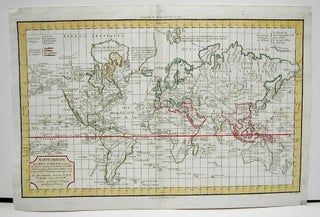
Paris: 1796. Size : 260x417 (mm), 10.25x16.375 (Inches), Coloring: Hand Colored in Outline, Category: Maps World. Size : 260x417 (mm), 10.25x16.375 (Inches), Coloring: Hand Colored in Outline, Category: Maps World.
Paris: Tardieu, 1817. Size : 290x390 (mm), 11.375x15.375 (Inches), Coloring: Hand Colored, Category: Maps World. Size : 290x390 (mm), 11.375x15.375 (Inches), Coloring: Hand Colored, Category: Maps World.
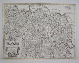
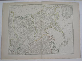
Paris: 1706. Size : 495x645 (mm), 19.5x25.375 (Inches), Coloring: Original Outline Coloring, Category: Maps Russia;; Maps Asia Continent. Size : 495x645 (mm), 19.5x25.375 (Inches), Coloring: Original Outline Coloring, Category: Maps Russia;; Maps Asia Continent.
Toronto: The Copp Clark Co., 1904. Notes: An impressive large scale and detailed map of the Northern part of Lake Superior. The maps also depicts the North West part of Lake Huron district of Nipissing, Algoma and Thunder Bay., Size : 750x1775 (mm), 29.5x69.875 (Inches), Coloring: Printed in Color, Category.....
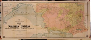
Toronto: The Clark Co Limited Litho, 1897. Notes: Northwest of Ontario, Size : 810x965 (mm), 31.875x38 (Inches), Coloring: Printed in Color, Category: Maps Canada Ontario North; Maps Geological. Notes: Northwest of Ontario, Size : 810x965 (mm), 31.875x38 (Inches), Coloring: Printed in Color, Category: Maps Canada Ontario North; Maps Geological.
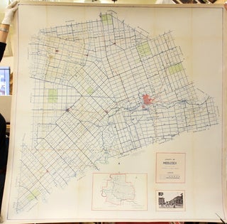
London, Ontario: Government of Ontario, 1901. Notes: Large scale and attractive wall map of the County of Middlesex published at the turn of the 20th century. The map shows highways, county sub-urban roads, county roads, Indian reserves, major cities, train lines & rivers and parks. The map also has two.....
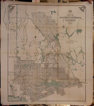
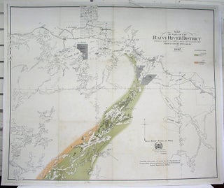
Ottawa: Department of Lands, Forests and Mines, 1908. Size : 1090x880 (mm), 42.875x34.625 (Inches), Coloring: Hand Colored, Category: Maps Wall Maps; Maps Canada Ontario Central;. Size : 1090x880 (mm), 42.875x34.625 (Inches), Coloring: Hand Colored, Category: Maps Canada Ontario Central Nipissing; Maps Wall Maps.
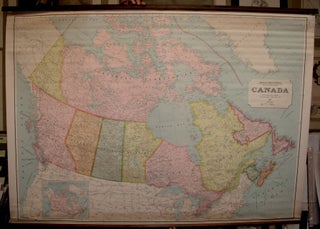
Canada: Department of Mines and Resources, 1947. Size : 1005x1400 (mm), 39.5x55.125 (Inches), Coloring: Printed in Color, Category: ; Maps Canada; Maps Wall Maps. Size : 1005x1400 (mm), 39.5x55.125 (Inches), Coloring: Printed in Color, Category: ; Maps Canada; Maps Wall Maps.
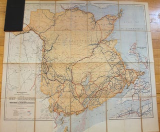
Canada: Department of the Interior, c. 1925. Notes: A scarce (preliminary edition) folding map of New Brunswick from the early 20th century. The map comes from the private library of Field Marshall Earl Haig and is in a black pebbled cloth case with his name printed on the top cover.....
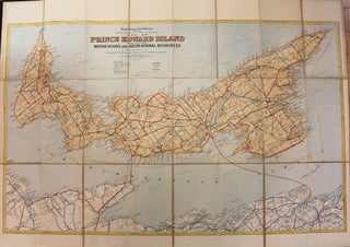
Canada: Department of the Interior, c. 1925. Notes: A scarce (preliminary edition) folding map of Prince Edward Island from the early 20th century. The map comes from the private library of Field Marshall Earl Haig and is in a black pebbled cloth case with his name printed on the top.....
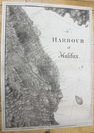
London: c.1781. Notes: scarce and superb sea chart constructed for the use of the British Navy shows The Harbour of Halifax, Nova Scotia, during the late 18th century. Colonel Joseph Frederick Wallet DesBarres (1721 – 1824) was a hydrographer, cartographer, military engineer and landscape artist who served in the Seven.....
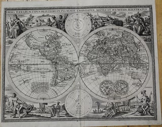
Germany: c.1675. Notes: A fine decorative World map with dark and strong impression. German text on verso. This World Map by Detleffsen, Johann (early state) published in Germany in 1675 was based on the earlier World map by Nicolaus Visscher for German Bibles in the middle of the 17th century.....