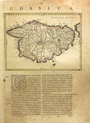
Corsica Insula
Amsterdam: c.1640. Notes: Map of Corsica Latin text., Size : 180x240 (mm), 7.09x9.45 (Inches), Coloring: Hand Colored, Reference: Koeman, Vol II: 7525.2A , Category: Maps Mediterranean Islands;.
Amsterdam: c.1640. Notes: Map of Corsica Latin text., Size : 180x240 (mm), 7.09x9.45 (Inches), Coloring: Hand Colored, Reference: Koeman, Vol II: 7525.2A , Category: Maps Mediterranean Islands;.

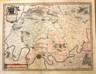
Amsterdam: c.1640. Notes: Decorative map of Holland regions of Rhineland and Amstelland., Size : 406x496 (mm), 15.98x19.53 (Inches), Coloring: Hand Colored, Category: Maps Europe Benelux;. Notes: Decorative map of Holland regions of Rhineland and Amstelland., Size : 406x496 (mm), 15.98x19.53 (Inches), Coloring: Hand Colored, Category: Maps Europe Benelux;.
Amsterdam: c.1640. Notes: Latin text on verso. Map of the region of Paris. Willem Janszoon Blaeu (1571-1638) was a Dutch cartographer, atlas maker, and publisher. Along with his son Johannes Blaeu, Willem is considered one of the notable figures of the Netherlandish or Dutch school of cartography during its golden.....
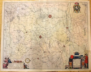
Amsterdam: c.1640. Notes: Latin text on verso. Map showing the vicinity of Leuven, Belgium. With decorative cartouche, numerous coats of arms, scale of miles, and several figures. The map was drawn for Blaeu by Michael Floris van Langren, the mathematician and astronomer to the King of Spain. Willem Janszoon Blaeu.....

Amsterdam: 1626. Notes: Detailed map of Prussia, northeastern Poland from about Gdansk to Lithuania, including the Russian enclave of Kaliningrad Oblast. French text on verso., Size : 380x480 (mm), 15x18.875 (Inches), Coloring: Original Hand Coloring, Category: Maps Europe Poland, Lithuania. Notes: French text on verso, Size : 380x480 (mm), 15x18.875.....