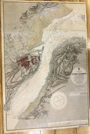
North America--East Coast River St. Lawrence Quebec Harbour
London: British Admiralty, 1917. Notes: Sea chart of Quebec city and River St. Lawrence., Size : 650x972 (mm), 25.59x38.27 (Inches), Coloring: Hand Colored, Category: Maps Canada East Quebec Quebec City; Maps City Maps; Maps Sea Chart;. Notes: Sea chart of Quebec city and River St. Lawrence., Size : 650x972 (mm).....

![Item #M10414 [Plymouth Harbour To Sandy Neck]. Sir W. J L. Wharton](https://alexandremaps.cdn.bibliopolis.com/pictures/M10414.jpg?width=320&height=427&fit=bounds&auto=webp&v=1646685226)