Plan and Elevation of the Union Bridges - Ottawa River, near the Falls of Chaudiere in 1827
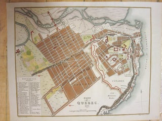
London: Day & Haghe, 1832. Notes: From Joseph Bouchette, British Dominions in North America., Size : 185x260 (mm), 7.25x10.25 (Inches), Coloring: Hand Colored, Category: Maps Canada Ontario East;. Notes: From Joseph Bouchette, British Dominions in North America., Size : 185x260 (mm), 7.25x10.25 (Inches), Coloring: Hand Colored, Category: Maps Canada Ontario.....