
Chart of the East India Isands.
London: 1800. Size : 242x376 (mm), 9.5x14.75 (Inches), Coloring: Hand Colored, Category: ; Maps Asia South East. Size : 242x376 (mm), 9.5x14.75 (Inches), Coloring: Hand Colored, Category: ; Maps Asia South East.
London: 1800. Size : 242x376 (mm), 9.5x14.75 (Inches), Coloring: Hand Colored, Category: ; Maps Asia South East. Size : 242x376 (mm), 9.5x14.75 (Inches), Coloring: Hand Colored, Category: ; Maps Asia South East.

London: 1834. Notes: Published by John Arrowsmith, founder member of the Royal Geographical Society. John Arrowsmith joined his uncle (Aaron) in 1810, but after his uncle's death he opened his own establishment. In 1795, his uncle published a large four-sheet map of North America which was dedicated to the Hudson's.....

London: 1834. Size : 630x510 (mm), 24.75x20.125 (Inches), Coloring: Original Outline Coloring, Category: ; Maps North America Great Lakes; Maps United States East. Size : 630x510 (mm), 24.75x20.125 (Inches), Coloring: Original Outline Coloring, Category: ; Maps North America Great Lakes; Maps United States East.

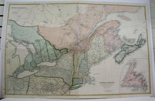
London: 1853. Notes: This is an important early map of upper Canada with districts and counties shown. Published by John Arrowsmith, founder member of the Royal Geographical Society. John Arrowsmith joined his uncle (Aaron) in 1810, but after his uncle's death he opened his own establishment. In 1795, his uncle.....
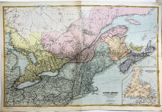
London: 1842. Notes: This is an important early map of upper and lower Canada with districts and counties shown. It focuses on the seperation between lower and upper Canada, and extends from Lake Superior and Lake Michigan in the West to Nova Scotia to the East. Also, the entire U.S......
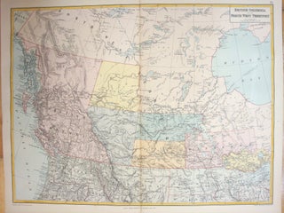
London: Edward Stanford, 1887. Notes: The map shows rivers, settlements, territories of First Nations peoples. Western Canada is illustrated with details based on early explorers. Early forts and trading houses are depicted , Size : 474x628 (mm), 18.66x24.72 (Inches), Coloring: Printed in Color with Some Hand Coloring, Category: Maps Canada.....
London: Edward Stanford, 1887. Size : 470x607 (mm), 18.50x23.90 (Inches), Coloring: Printed in Color with Some Hand Coloring, Category: Maps Asia Near East Turkey;. Size : 470x607 (mm), 18.50x23.90 (Inches), Coloring: Printed in Color with Some Hand Coloring, Category: Maps Asia Near East Turkey;.
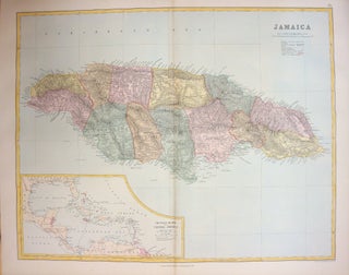
London: Edward Stanford, 1887. Size : 472x600 (mm), 18.58x23.62 (Inches), Coloring: Printed in Color with Some Hand Coloring, Category: Maps West Indies Other Islands;. Size : 472x600 (mm), 18.58x23.62 (Inches), Coloring: Printed in Color with Some Hand Coloring, Category: Maps West Indies Jamaica;.
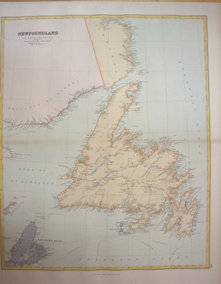
London: Edward Stanford, 1887. Size : 588x484 (mm), 23.15x19.06 (Inches), Coloring: Printed in Color with Some Hand Coloring, Category: Maps Canada East Newfoundland;Maps Canada East Quebec;. Size : 588x484 (mm), 23.15x19.06 (Inches), Coloring: Printed in Color with Some Hand Coloring, Category: Maps Canada East Newfoundland;Maps Canada East Quebec;.
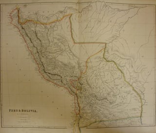
London: J. Arrowsmith, 1834. Size : 644x525 (mm), 25.35x20.67 (Inches), Coloring: Original Outline Coloring, Category: Maps South America Countries;. Size : 644x525 (mm), 25.35x20.67 (Inches), Coloring: Original Outline Coloring, Category: Maps South America Bolivia;Maps South America Peru;.
London: Stanford\\\'s Geographical Establishment, c. 1870. Notes: An importatn late 19th Century map of Upper Canada and Eastern Provinces by the renowed English family of map makers, Arrowsmith. , Size : 607x950 (mm), 23.90x37.40 (Inches), Coloring: Original Hand Coloring, Category: Maps Canada East Quebec; Maps Canada Ontario; Maps Canada East.....
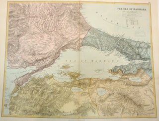
London: Edward Stanford, c. 1887. Notes: Where available, place names are given in various languages: for instance, the Black Sea is also given in its Turkish form "Kara Dengiz" and its Latin form "Pontus Euxinus"; Constantinople is also written as "Stamboul" and "Byzantium")., Size : 470x610 (mm), 18.50x24.02 (Inches), Coloring.....
London: J. Arrowsmith, 1842. Notes: A rather important 19th century map of Upper and Lower Canadas and the Maritimes. Published by John Arrowsmith, founder member of the Royal Geographical Society. John Arrowsmith joined his uncle (Aaron) in 1810, but after his uncle's death he opened his own establishment. In 1795.....
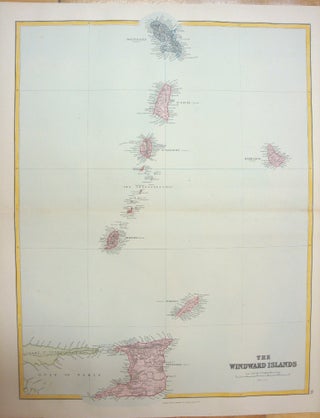
London: Edward Stanford, 1887. Size : 474x605 (mm), 18.66x23.82 (Inches), Coloring: Printed in Color with Some Hand Coloring, Category: Maps West Indies Whole;. Size : 474x605 (mm), 18.66x23.82 (Inches), Coloring: Printed in Color with Some Hand Coloring, Category: Maps West Indies Whole;.
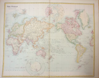
London: Edward Stanford, 1887. Notes: The map displays in relief cross-sections of the continents, visually displaying the height of land in relation to sea-level. Below, two relief cross-sections demonstrate the height of mountains and depth of oceans, one along the Equator, the other along the 110th degree W and 70th.....
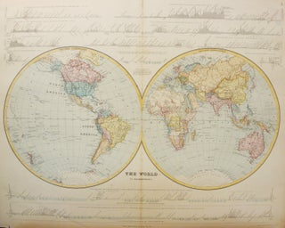
London: Edward Stanford, 1887. Size : 490x604 (mm), 19.29x23.78 (Inches), Coloring: Printed in Color with Some Hand Coloring, Category: Maps World;. Size : 490x604 (mm), 19.29x23.78 (Inches), Coloring: Printed in Color with Some Hand Coloring, Category: Maps World;.
London: John Arrowsmith, 1854. Size : 245x495 (mm), 9.625x19.5 (Inches), Coloring: Hand Colored, Category: Maps Folding Map;; Maps Military; Maps Europe Ukraine. Size : 245x495 (mm), 9.625x19.5 (Inches), Coloring: Hand Colored, Category: Maps Folding Map;; Maps Military; Maps Europe Ukraine.
Longman Hurst Rees and Orne Paternoster Row, c. 1809. Notes: From 1797 to 1800 the mapping of the far flung trading stations that were operated by the Hudson’s Bay Company was finished. Also, mapping of the areas of Manitoba, Saskatchewan, and the United States to the head waters of the.....