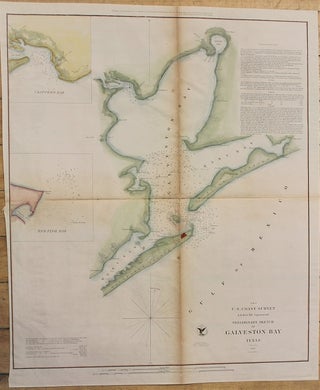
No.2 U.S. Coast Survey Preliminary Sketch of Galveston Bay Texas
USA: U.S. Coast Survey / U.S. Navy, 1852. Size : 490x423 (mm), 19.29x16.65 (Inches), Coloring: Hand Colored, Category: Maps United States South Texas;.
USA: U.S. Coast Survey / U.S. Navy, 1852. Size : 490x423 (mm), 19.29x16.65 (Inches), Coloring: Hand Colored, Category: Maps United States South Texas;.
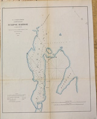
USA: U.S. Coast Survey / U.S. Navy, 1860. Size : 378x312 (mm), 14.88x12.28 (Inches), Coloring: Hand Colored, Category: Maps Canada East Newfoundland;. Size : 378x312 (mm), 14.88x12.28 (Inches), Coloring: Hand Colored, Category: Maps Canada East Newfoundland;.
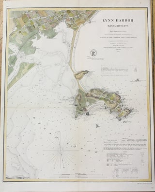
Baltimore, USA: Survey of the Coast of the United States, 1870. Size : 488x445 (mm), 19.21x17.52 (Inches), Coloring: Hand Colored, Category: Maps United States New England (States);. Size : 488x445 (mm), 19.21x17.52 (Inches), Coloring: Hand Colored, Category: Maps United States New England Massachusetts;.
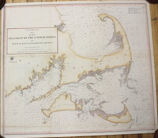
USA: Survey of the Coast of the United States, c.1857. Notes: Map Showing Cape Cod, Martha's Vineyard and Nantucket Island., Size : 545x624 (mm), 21.46x24.57 (Inches), Coloring: Hand Colored, Category: Maps United States New England (States);. Notes: Map Showing Cape Cod, Martha's Vineyard and Nantucket Island., Size : 545x624 (mm).....
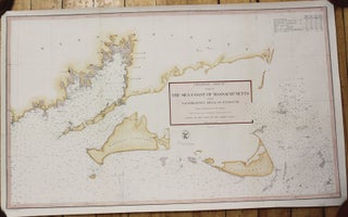
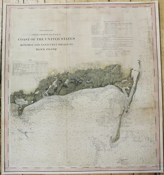
USA: Survey of the Coast of the United States, c.1856. Notes: Map showing the sea coast of Massachusetts, Martha's Vineyard and Nantucket Island., Size : 386x656 (mm), 15.20x25.83 (Inches), Coloring: Hand Colored, Category: Maps United States New England (States);. Notes: Map showing the sea coast of Massachusetts, Martha's Vineyard and.....
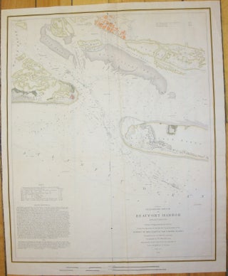
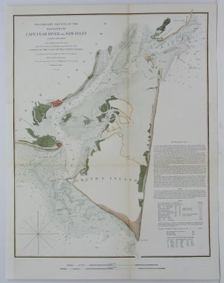
U.S.A. Survey of the Coast of the United States, 1851. Size : 433x355 (mm), 17.05x13.98 (Inches), Coloring: Hand Colored, Category: Maps United States East (Carolinas);. Size : 433x355 (mm), 17.05x13.98 (Inches), Coloring: Hand Colored, Category: Maps United States East North Carolina;.
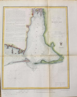
U.S.A. U.S. Coast Survey, 1852. Size : 420x337 (mm), 16.54x13.27 (Inches), Coloring: Hand Colored, Category: Maps United States South (States);. Size : 420x337 (mm), 16.54x13.27 (Inches), Coloring: Hand Colored, Category: Maps United States South Alabama;.
Washington, D.C. US Coast Survey, 1856. Notes: With an inset map: Sub-Sketch showing the progress of the Survey of St.John's River. , Size : 414x412 (mm), 16.30x16.22 (Inches), Coloring: Hand Colored, Category: Maps United States South Florida;. Notes: With an inset map: Sub-Sketch showing the progress of the Survey of.....
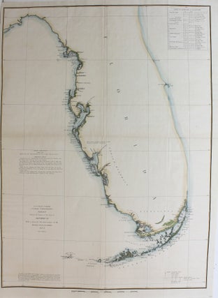
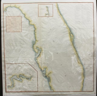
USA: c.1851. Notes: Map of Florida during the mid 19th century. , Size : 574x420 (mm), 22.60x16.54 (Inches), Coloring: Hand Colored, Category: Maps United States South Florida;. Notes: Map of Florida during the mid 19th century. , Size : 574x420 (mm), 22.60x16.54 (Inches), Coloring: Hand Colored, Category: Maps United States.....

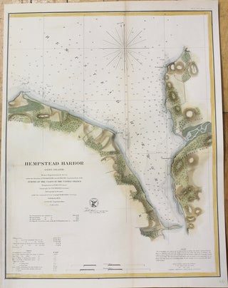
U.S. 1851. Size : 380x670 (mm), 15x26.375 (Inches), Coloring: Hand Colored, Category: ; Maps United States East New York Long Island. Size : 380x670 (mm), 15x26.375 (Inches), Coloring: Hand Colored, Category: ; Maps United States East New York Long Island.
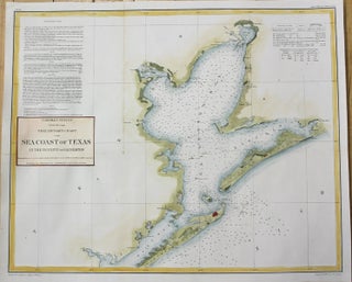
New York: US Coast Survey, c.1856. Size : 406x502 (mm), 15.98x19.76 (Inches), Coloring: Hand Colored, Category: Maps United States South Texas;. Size : 406x502 (mm), 15.98x19.76 (Inches), Coloring: Hand Colored, Category: Maps United States South Texas;.
USA: Survey of the Coast of the United States, c.1859. Size : 442x367 (mm), 17.40x14.45 (Inches), Coloring: Hand Colored, Category: Maps United States New England (States);. Size : 442x367 (mm), 17.40x14.45 (Inches), Coloring: Hand Colored, Category: Maps United States New England Massachusetts;.
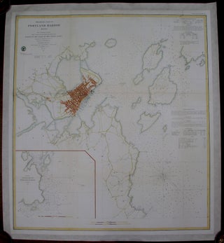
US: 1859. Size : 725x660 (mm), 28.5x26 (Inches), Coloring: Hand Colored, Category: Maps United States New England (States);. Size : 725x660 (mm), 28.5x26 (Inches), Coloring: Hand Colored, Category: ; Maps United States New England Maine.
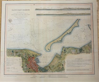
USA: Survey of the Coast of the United States, 1866. Notes: Nautical charts of Nantucket Harbor in Massachusetts., Size : 362x446 (mm), 14.25x17.56 (Inches), Coloring: Hand Colored, Category: Maps United States New England (States);.
US: 1853. Size : 430x350 (mm), 16.875x13.75 (Inches), Coloring: Hand Colored, Category: Maps United States East (Carolinas);. Size : 430x350 (mm), 16.875x13.75 (Inches), Coloring: Hand Colored, Category: ; Maps United States East North Carolina.
USA: Survey of the Coast of the United States, c.1859. Size : 455x355 (mm), 17.91x13.98 (Inches), Coloring: Hand Colored, Category: Maps United States East New York Long Island;. Size : 455x355 (mm), 17.91x13.98 (Inches), Coloring: Hand Colored, Category: Maps United States East New York Long Island;.
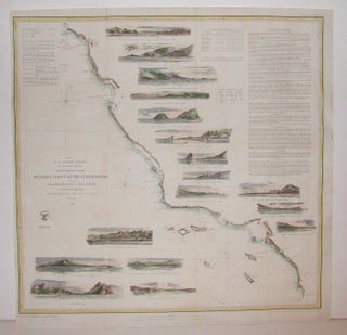
Washington, D.C. US Coast Survey, 1853. Size : 366x445 (mm), 14.41x17.52 (Inches), Coloring: Hand Colored, Category: Maps United States West Washington & Oregon;. Size : 366x445 (mm), 14.41x17.52 (Inches), Coloring: Hand Colored, Category: Maps United States West Washington;.

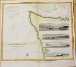
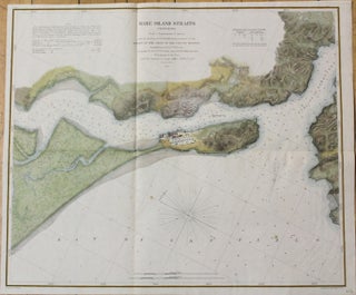
Washington, D.C. Survey of the Coast of the United States, 1853. Notes: Map showing the coast of Cape Flattery, Washington and Neah Bay., Size : 340x430 (mm), 13.39x16.93 (Inches), Coloring: Hand Colored, Category: Maps United States West Washington & Oregon;. Notes: Map showing the coast of Cape Flattery, Washington and.....
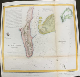
Washington, D.C. US Coast Survey, 1853. Size : 295x325 (mm), 11.61x12.80 (Inches), Coloring: Hand Colored, Category: Maps United States West California;. Size : 295x325 (mm), 11.61x12.80 (Inches), Coloring: Hand Colored, Category: Maps United States West California;.
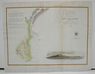
Washington, D.C. Survey of the Coast of the United States, 1857. Size : 366x438 (mm), 14.41x17.24 (Inches), Coloring: Hand Colored, Category: Maps United States West California;. Size : 366x438 (mm), 14.41x17.24 (Inches), Coloring: Hand Colored, Category: Maps United States West California;.
United States: U.S. Coast Survey / U.S. Navy, 1854. Size : 587x567 (mm), 23.125x22.25 (Inches), Coloring: Hand Colored, Category: ; Maps United States West. Size : 587x567 (mm), 23.125x22.25 (Inches), Coloring: Hand Colored, Category: ; Maps United States West.
United States: U.S. Coast Survey / U.S. Navy, 1855. Size : 619x568 (mm), 24.375x22.375 (Inches), Coloring: Hand Colored, Category: Maps United States West Washington & Oregon;. Size : 619x568 (mm), 24.375x22.375 (Inches), Coloring: Hand Colored, Category: ; Maps United States West Oregon; Maps United States West Washington.
United States: U.S. Coast Survey / U.S. Navy, 1852. Size : 557x577 (mm), 21.875x22.75 (Inches), Coloring: Hand Colored, Category: Maps United States West California. Size : 557x577 (mm), 21.875x22.75 (Inches), Coloring: Hand Colored, Category: Maps United States West California.
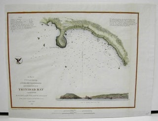
United States: U.S. Coast Survey / U.S. Navy, 1852. Size : 240x333 (mm), 9.5x13.125 (Inches), Coloring: Hand Colored, Category: Maps United States West California. Size : 240x333 (mm), 9.5x13.125 (Inches), Coloring: Hand Colored, Category: Maps United States West California.
United States: U.S. Coast Survey / U.S. Navy, 1851. Size : 203x269 (mm), 8x10.625 (Inches), Coloring: Hand Colored, Category: Maps United States West California; Maps Sea Chart. Size : 203x269 (mm), 8x10.625 (Inches), Coloring: Hand Colored, Category: Maps United States West California; Maps Sea Chart.