
The Bay of Agoa de Saldanha
London: 1752. Size : 122x90 (mm), 4.75x3.5 (Inches), Coloring: Hand Colored, Category: Maps Africa South. Size : 122x90 (mm), 4.75x3.5 (Inches), Coloring: Hand Colored, Category: Maps Africa South.
London: 1752. Size : 122x90 (mm), 4.75x3.5 (Inches), Coloring: Hand Colored, Category: Maps Africa South. Size : 122x90 (mm), 4.75x3.5 (Inches), Coloring: Hand Colored, Category: Maps Africa South.

London: 1752. Size : 86x129 (mm), 3.375x5.125 (Inches), Coloring: Hand Colored, Category: Maps West Indies Other Islands;. Size : 86x129 (mm), 3.375x5.125 (Inches), Coloring: Hand Colored, Category: Maps West Indies Martinique.

London: 1747. Size : 57x66 (mm), 2.25x2.625 (Inches), Coloring: Hand Colored, Category: Maps West Indies Cuba & Bahamas;. Size : 57x66 (mm), 2.25x2.625 (Inches), Coloring: Hand Colored, Category: Maps West Indies Bahamas.

London: 1752. Size : 104x140 (mm), 4.125x5.5 (Inches), Coloring: Hand Colored, Category: Maps Europe Portugal;. Size : 104x140 (mm), 4.125x5.5 (Inches), Coloring: Hand Colored, Category: Maps Europe Portugal;.

London: 1752. Size : 133x120 (mm), 5.25x4.75 (Inches), Coloring: Hand Colored, Category: Maps Europe Spain;. Size : 133x120 (mm), 5.25x4.75 (Inches), Coloring: Hand Colored, Category: Maps Europe Spain;.

London: William Innys, 1747. Size : 355x215 (mm), 14x8.5 (Inches), Coloring: Hand Colored in Outline, Reference: Tooley Bermuda pg. 11, Category: Maps West Indies Other Islands;. Size : 355x215 (mm), 14x8.5 (Inches), Coloring: Hand Colored in Outline, Reference: Tooley Bermuda pg. 11, Category: Maps West Indies Bermuda.
London: William Collins, 1945. Binding: Illustrated publisher’s paper boards., Size: 8vo. , Illustration: Illustrated with 8 plates and 19 illustrations. , Category: Book Literature; Book Bibliography & Reference Books;. Binding: Illustrated publisher’s paper boards., Size: 8vo. , Illustration: Illustrated with 8 plates and 19 illustrations. , Category: Book Literature; Book.....
London: 1747. Size : 57x66 (mm), 2.25x2.625 (Inches), Coloring: Hand Colored, Category: Maps West Indies Cuba & Bahamas;. Size : 57x66 (mm), 2.25x2.625 (Inches), Coloring: Hand Colored, Category: Maps West Indies Cuba.

London: 1747. Size : 135x147 (mm), 5.25x5.75 (Inches), Coloring: Hand Colored, Category: Maps United States New England Massachusetts Boston;. Size : 135x147 (mm), 5.25x5.75 (Inches), Coloring: Hand Colored, Category: Maps United States New England Massachusetts Boston;.

London: 1752. Size : 59x71 (mm), 2.375x2.75 (Inches), Coloring: Hand Colored, Category: ; Maps United States South Florida. Size : 59x71 (mm), 2.375x2.75 (Inches), Coloring: Hand Colored, Category: ; Maps United States South Florida.

London: 1747. Size : 57x69 (mm), 2.25x2.75 (Inches), Coloring: Hand Colored, Category: Maps West Indies Cuba & Bahamas;. Size : 57x69 (mm), 2.25x2.75 (Inches), Coloring: Hand Colored, Category: Maps West Indies Cuba;.

London: 1752. Size : 362x431 (mm), 14.25x17 (Inches), Coloring: Hand Colored in Outline, Category: Maps South America Countries;. Size : 362x431 (mm), 14.25x17 (Inches), Coloring: Hand Colored in Outline, Category: Maps South America Peru; Maps South America Brazil.

London: 1747. Notes: Detailed map of Hungary and Translivania region. , Size : 354x434 (mm), 13.875x17.125 (Inches), Coloring: Hand Colored, Category: ; Maps Europe Hungary; Maps Europe Romania. Size : 354x434 (mm), 13.875x17.125 (Inches), Coloring: Black & White, Category: ; Maps Europe Hungary; Maps Europe Romania.

London: 1752. Size : 117x123 (mm), 4.625x4.875 (Inches), Coloring: Hand Colored, Category: Maps Africa South. Size : 117x123 (mm), 4.625x4.875 (Inches), Coloring: Hand Colored, Category: Maps Africa South.

London: 1747. Size : 87x149 (mm), 3.375x5.875 (Inches), Coloring: Hand Colored, Category: Maps Central America Countries;. Size : 87x149 (mm), 3.375x5.875 (Inches), Coloring: Hand Colored, Category: Maps Central America Countries;.

London: 1747. Size : 137x151 (mm), 5.375x6 (Inches), Coloring: Hand Colored, Category: Maps Canada East Nova Scotia;. Size : 137x151 (mm), 5.375x6 (Inches), Coloring: Hand Colored, Category: Maps Canada East Nova Scotia;.
London: 1773. Notes: Engraved by Thomas Bowen, Size : 322x447 (mm), 12.625x17.625 (Inches), Coloring: Hand Colored, Category: ; Maps South America Continent. Notes: Engraved by Thomas Bowen, Size : 322x447 (mm), 12.625x17.625 (Inches), Coloring: Hand Colored, Category: ; Maps South America Continent.
London: Middleton, 1778. Notes: "Engraved for Middleton's Complete System of Geogrpahy", Size : 220x285 (mm), 8.625x11.25 (Inches), Coloring: Hand Colored, Category: ; Maps Sea Chart; Maps Ocean Atlantic. Notes: "Engraved for Middleton's Complete System of Geogrpahy", Size : 220x285 (mm), 8.625x11.25 (Inches), Coloring: Hand Colored, Category: ; Maps Sea Chart;.....
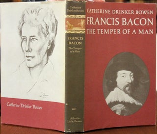
Toronto: Little, Brown and Company, 1963. Binding: Original cloth boards with dust jacket, Illustration: Illustrated with some black and white plates., Pages: P.3-245, Category: Book Biography;. Binding: Original cloth boards with dust jacket, Illustration: Illustrated with some black and white plates., Pages: P.3-245, Category: Book Biography;.

London: 1738. Notes: An important map showing the vicinity of Hong Kong in 1738., Size : 370x240 (mm), 14.5x9.5 (Inches), Coloring: Hand Colored in Outline, Category: Maps Asia Far East China. Notes: An important map showing the vicinity of Hong Kong in 1738., Size : 370x240 (mm), 14.5x9.5 (Inches), Coloring.....
London: 1738. Size : 385x235 (mm), 15.125x9.25 (Inches), Coloring: Black & White, Category: Maps Asia Far East China. Size : 385x235 (mm), 15.125x9.25 (Inches), Coloring: Black & White, Category: Maps Asia Far East China.

London: 1738. Size : 390x240 (mm), 15.375x9.5 (Inches), Coloring: Black & White, Category: Maps Asia Far East China. Size : 390x240 (mm), 15.375x9.5 (Inches), Coloring: Black & White, Category: Maps Asia Far East China.

London: 1738. Size : 380x235 (mm), 15x9.25 (Inches), Coloring: Black & White, Category: Maps Asia Far East China. Size : 380x235 (mm), 15x9.25 (Inches), Coloring: Black & White, Category: Maps Asia Far East China.

London: 1738. Size : 385x235 (mm), 15.125x9.25 (Inches), Coloring: Black & White, Category: Maps Asia Far East China. Size : 385x235 (mm), 15.125x9.25 (Inches), Coloring: Black & White, Category: Maps Asia Far East China.

London: 1738. Size : 380x235 (mm), 15x9.25 (Inches), Coloring: Black & White, Category: Maps Asia Far East China. Size : 380x235 (mm), 15x9.25 (Inches), Coloring: Black & White, Category: Maps Asia Far East China.