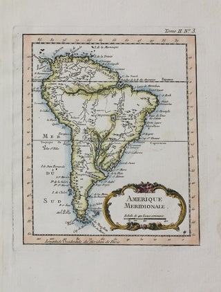
Amerique Meridionale
Paris: 1760. Size : 208x180 (mm), 8.19x7.09 (Inches), Coloring: Hand Colored, Category: Maps South America Continent;. Size : 208x180 (mm), 8.19x7.09 (Inches), Coloring: Hand Colored, Category: Maps South America Continent;.
Paris: 1760. Size : 208x180 (mm), 8.19x7.09 (Inches), Coloring: Hand Colored, Category: Maps South America Continent;. Size : 208x180 (mm), 8.19x7.09 (Inches), Coloring: Hand Colored, Category: Maps South America Continent;.
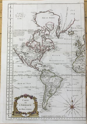
Paris: 1763. Size : 464x310 (mm), 18.27x12.20 (Inches), Coloring: Hand Colored in Outline, Category: Maps North America; Maps South America Continent;. Size : 464x310 (mm), 18.27x12.20 (Inches), Coloring: Hand Colored in Outline, Category: Maps North America; Maps South America Continent;.
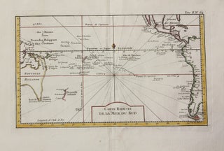
Paris: c.1753. Size : 230x370 (mm), 9.06x14.57 (Inches), Coloring: Hand Colored, Category: Maps South America Continent; Maps Ocean Pacific; Maps Pacific;. Size : 230x370 (mm), 9.06x14.57 (Inches), Coloring: Hand Colored, Category: Maps Oceania (Pacific) Polynesia; Maps Oceania (Pacific) Australia; Maps Oceania (Pacific) New Zealand; Maps South America Continent; Maps Central.....
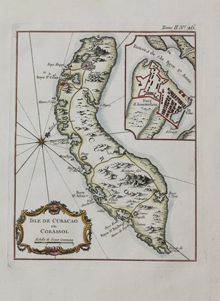
Paris: c.1760. Notes: Map of Curacao, with an inset plan of Fort Amsterdam., Size : 227x180 (mm), 8.94x7.09 (Inches), Coloring: Hand Colored, Category: Maps West Indies Whole;. Notes: Map of Curacao, with an inset plan of Fort Amsterdam., Size : 227x180 (mm), 8.94x7.09 (Inches), Coloring: Hand Colored, Category: Maps West.....
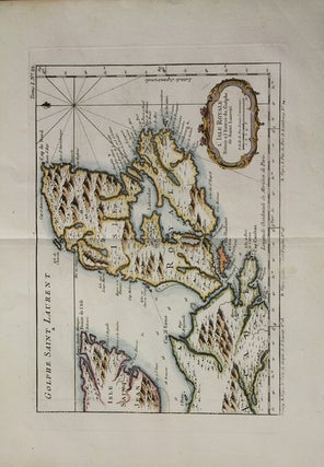
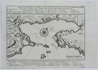
Paris: 1764. Notes: A fine map of what was formerly known as L'Isle Royale (Cape Breton Island), off the coast of Acadia. Jacques Nicolas Bellin (1703-1772) was a French hydrographer, geographer, and member of the French intellectual group called the philosophes. Bellin was born in Paris. He was hydrographer of.....
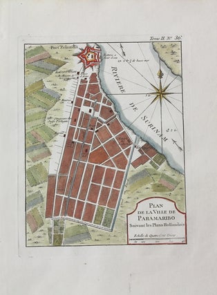
Paris: c.1750. Notes: Paramaribo is the capital city of Suriname on the banks of the Suriname River., Size : 228x179 (mm), 8.98x7.05 (Inches), Coloring: Hand Colored, Category: Maps South America Countries;. Notes: Paramaribo is the capital city of Suriname on the banks of the Suriname River., Size : 228x179 (mm).....
Paris: c.1744. Size : 228x181 (mm), 8.98x7.13 (Inches), Coloring: Hand Colored, Category: Maps Central America Countries;. Size : 228x181 (mm), 8.98x7.13 (Inches), Coloring: Hand Colored, Category: Maps Central America Countries;.
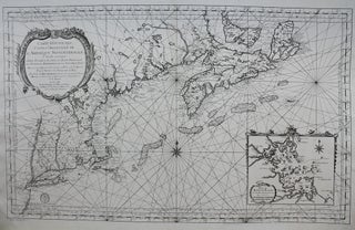
Paris: Department de la Marine, 1757. Notes: A magnificent mid 18th century sea chart of the Atlantic coast of north eastern United States, stretching from Cape Breton to New Jersey. Rivers, mountain ranges, lakes, and coastal features are depicted in fine detail. With an inset of the Boston and vicinity.....

Leipzig: 1756. Notes: Published in "Allegmeine Historie der Reisen zu Wasser und zu Lande", Size : 229x295 (mm), 9x11.625 (Inches), Coloring: Black & White, Reference: Kershaw 518, Category: Maps Canada East Newfoundland. Notes: Published in "Allegmeine Historie der Reisen zu Wasser und zu Lande", Size : 229x295 (mm), 9x11.625 (Inches).....
Germany: 1757. Notes: Published in "Allegmeine Historie der Reisen zu Wasser und zu Lande", Size : 223x295 (mm), 8.75x11.625 (Inches), Coloring: Black & White, Reference: Kershaw 771, Category: Maps Canada East Nova Scotia. Notes: Published in "Allegmeine Historie der Reisen zu Wasser und zu Lande", Size : 223x295 (mm), 8.75x11.625.....
Germany: 1757. Notes: Published in "Allegmeine Historie der Reisen zu Wasser und zu Lande", Size : 233x295 (mm), 9.125x11.625 (Inches), Coloring: Black & White, Reference: Kershaw 772, Category: Maps Canada East Nova Scotia. Notes: Published in "Allegmeine Historie der Reisen zu Wasser und zu Lande", Size : 233x295 (mm), 9.125x11.625.....
1756. Notes: Published in "Allegmeine Historie der Reisen zu Wasser und zu Lande", Size : 230x295 (mm), 9x11.625 (Inches), Coloring: Black & White, Reference: Kershaw 770, Category: Maps Canada East Nova Scotia. Notes: Published in "Allegmeine Historie der Reisen zu Wasser und zu Lande", Size : 230x295 (mm), 9x11.625 (Inches).....
Leipzig: 1756. Notes: Published in "Allegmeine Historie der Reisen zu Wasser und zu Lande", Size : 214x305 (mm), 8.375x12 (Inches), Coloring: Black & White, Reference: Kershaw 520, Category: Maps Canada East Newfoundland. Notes: Published in "Allegmeine Historie der Reisen zu Wasser und zu Lande", Size : 214x305 (mm), 8.375x12 (Inches).....
Leipzig: 1756. Notes: Published in "Allegmeine Historie der Reisen zu Wasser und zu Lande", Size : 230x290 (mm), 9x11.375 (Inches), Coloring: Black & White, Reference: Kershaw 887, Category: Maps Canada East Nova Scotia. Notes: Published in "Allegmeine Historie der Reisen zu Wasser und zu Lande", Size : 230x290 (mm), 9x11.375.....
London: Gentleman's Magazine, 1746. Notes: Decorative and detailed map of East Coast with the inset maps of Quebec City, city & ports of Louisburg and fort Dauphin. Thomas Jefferys mid-18th-century English map of East coast of Canada after Bellin, nicely framed., Size : 342x469 (mm), 13.46x18.46 (Inches), Coloring: Hand Colored.....
The Netherlands: c. 1760. Notes: Engraved by Jacob van der Schley. It depicts the coast of Mozambique and an early projection of the course of the Zambezi and Limpopo Rivers; giving us an impression as to how present-day Zimbabwe, northeastern South Africa, Swaziland, and Mozambique were thought to look like......
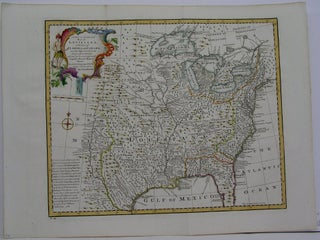
London: 1747. Notes: "Covers the area from Quebec to the Gulf of Mexico and west to Santa Fe, N. M. Shows towns and cities, forts, trails, Indian villiages and tribal territory, some vegetation, and relief" The plate number 59 in the lower left identifies the plate as being publishe in.....
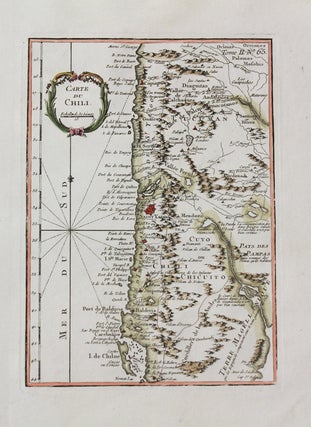
Paris: 1762-1764. Size : 249x178 (mm), 9.80x7.01 (Inches), Coloring: Hand Colored, Category: Maps South America Countries;. Size : 249x178 (mm), 9.80x7.01 (Inches), Coloring: Hand Colored, Category: Maps South America Chile;.
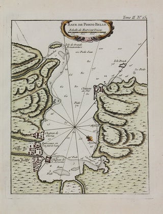
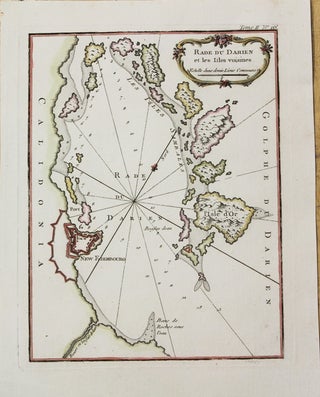
Paris: 1762-1764. Notes: Map of of Portobello (Panama)., Size : 225x180 (mm), 8.86x7.09 (Inches), Coloring: Hand Colored, Category: Maps Central America Countries;.
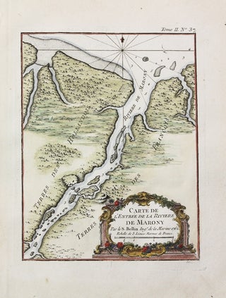
Paris: 1762-1764. Notes: Map showing the Dutch colony of Suriname surrounding the Suriname and Commewijne river systems. , Size : 226x428 (mm), 8.90x16.85 (Inches), Coloring: Hand Colored, Category: Maps South America Countries;. Notes: Map showing the Dutch colony of Suriname surrounding the Suriname and Commewijne river systems. , Size...
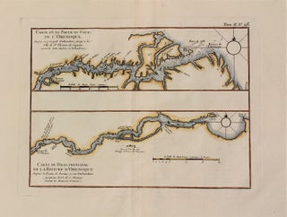
Paris: 1762-1764. Notes: Map of the course of Orenoque river. The Orinoco is one of the longest rivers in South America, Size : 235x315 (mm), 9.25x12.40 (Inches), Coloring: Hand Colored, Category: Maps South America Countries;.
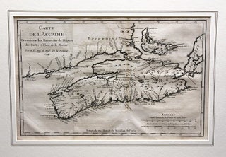
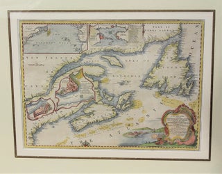
Paris: 1744. Notes: Map of Acadia by Jacques-Nicolas Bellin (1703-1772), French cartographer. Acadia was a colony of New France in northeastern North America which included parts of what are now the Maritime provinces, the Gaspe Peninsula and Maine to the Kennebec River., Size : 210x326 (mm), 8.27x12.83 (Inches), Coloring: Black.....
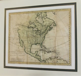
Paris: 1743. Notes: Important map of North America showing definitive and highly direct water route from Lake Superior to the Pacific Ocean [River of the West], finely framed., Size : 278x350 (mm), 10.94x13.78 (Inches), Coloring: Hand Colored, Category: Maps North America; Maps Central America Countries;.
Paris: 1762-1764. Notes: Map of Surinam., Size : 222x173 (mm), 8.74x6.81 (Inches), Coloring: Hand Colored, Category: Maps South America Countries;.
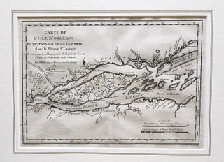
Paris: 1744. Notes: Map showing the Ile d'Orleans in St. Lawrence River by J. N. Bellin (1703-1772)., Size : 202x285 (mm), 7.95x11.22 (Inches), Coloring: Black & White, Category: Maps Canada East Quebec St. Lawrence River;.